
Carte topographique Pyramid Peak
Carte interactive
Cliquez sur la carte pour afficher l’altitude.
À propos de cette carte
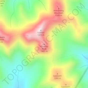
Nom : Carte topographique Pyramid Peak, altitude, relief.
Lieu : Pyramid Peak, Essex County, New York, USA (44.12347 -73.85599 44.12357 -73.85589)
Altitude moyenne : 1 084 m
Altitude minimum : 801 m
Altitude maximum : 1 441 m
Autres cartes topographiques
Cliquez sur une carte pour visualiser sa topographie, son altitude et son relief.
Graham
USA > New York > Town of Mount Pleasant > Graham
Graham, Town of Mount Pleasant, Westchester County, New York, 10532, USA
Altitude moyenne : 111 m
Flat Top Mountain
Flat Top Mountain, Franklin County, New York, USA
Altitude moyenne : 568 m
Livingston Island
Livingston Island, Town of Philipstown, Putnam County, New York, 10922, USA
Altitude moyenne : 156 m
Avalanche Lake
Avalanche Lake, Avalanche Pass Trail, Essex County, New York, USA
Altitude moyenne : 1 066 m
Roosevelt Island
USA > New York > New York City
Roosevelt Island, Manhattan Community Board 8, New York County, New York City, New York, 10044, USA
Altitude moyenne : 13 m
Falls Creek
Falls Creek, Town of Delhi, Delaware County, New York, 13753, USA
Altitude moyenne : 515 m
Midtown South
USA > New York > New York City
Midtown South, Manhattan, Manhattan Community Board 5, New York County, New York City, New York, 10118, USA
Altitude moyenne : 20 m
Farmingville
USA > New York > Farmingville
Farmingville, Suffolk County, New York, 11738, USA
Altitude moyenne : 47 m