
Carte topographique Nizhny Tagil
Carte interactive
Cliquez sur la carte pour afficher l’altitude.
À propos de cette carte
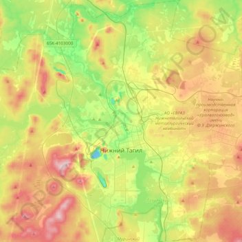
Nom : Carte topographique Nizhny Tagil, altitude, relief.
Altitude moyenne : 234 m
Altitude minimum : 121 m
Altitude maximum : 377 m
Rivers and ponds take up one third of the city's territory. Nizhny Tagil spans 22 kilometers (14 mi) from north to south and 21 kilometers (13 mi) from east to west. The altitude of the city varies from 170 to 380 meters (560 to 1,250 ft).
Autres cartes topographiques
Cliquez sur une carte pour visualiser sa topographie, son altitude et son relief.
Тагил
Russia > Sverdlovsk Oblast > городской округ Нижний Тагил > Nizhny Tagil
Тагил, Выя, Ленинский район, Nizhny Tagil, городской округ Нижний Тагил, Sverdlovsk Oblast, Ural Federal District, 622001, Russia
Altitude moyenne : 203 m