
Faire un don
Équipez-vous pour votre prochaine aventure :
En tant que Partenaire Amazon, ce site perçoit une commission sur les achats éligibles sans surcoût pour vous.
Carte topographique Corinaldo
Cliquez sur la carte pour afficher l’altitude.
Faire un don
Équipez-vous pour votre prochaine aventure :
En tant que Partenaire Amazon, ce site perçoit une commission sur les achats éligibles sans surcoût pour vous.
Corinaldo
At the end of the works, the new theater was very spacious and functional. According to Quagliani's design, an ingenious device was also prepared capable of making the stalls mobile, which was lowered on the occasion of theatrical performances and raised to create a single stage with the stage for dance parties and masked balls. After the 2006 restoration it definitively loses all its gadgets, from the elevation of the stalls to the stage machinery.
Faire un don
Équipez-vous pour votre prochaine aventure :
En tant que Partenaire Amazon, ce site perçoit une commission sur les achats éligibles sans surcoût pour vous.
À propos de cette carte
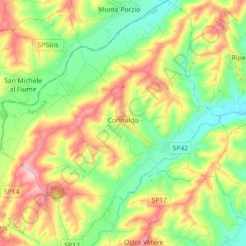
Nom : Carte topographique Corinaldo, altitude, relief.
Lieu : Corinaldo, Ancona, Marche, 60013, Italy (43.60236 12.98411 43.69304 13.10124)
Altitude moyenne : 133 m
Altitude minimum : 45 m
Altitude maximum : 265 m
Faire un don
Équipez-vous pour votre prochaine aventure :
En tant que Partenaire Amazon, ce site perçoit une commission sur les achats éligibles sans surcoût pour vous.