
Carte topographique Δήμος Αίγινας
Carte interactive
Cliquez sur la carte pour afficher l’altitude.
À propos de cette carte
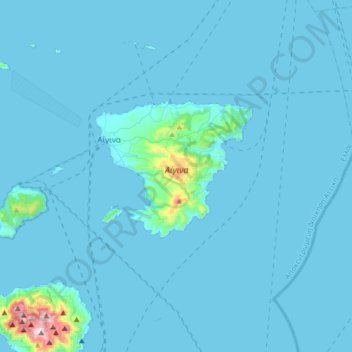
Nom : Carte topographique Δήμος Αίγινας, altitude, relief.
Altitude moyenne : 26 m
Altitude minimum : -1 m
Altitude maximum : 721 m
Autres cartes topographiques
Cliquez sur une carte pour visualiser sa topographie, son altitude et son relief.
Μετώπη
Griechenland > Attika > Regionalbezirk Inseln > Σκάλα
Μετώπη, Σκάλα, Δήμος Αγκιστρίου, Regionalbezirk Inseln, Region Attika, Attika, 180 10, Griechenland
Altitude moyenne : 0 m
Methana
Griechenland > Attika > Regionalbezirk Inseln > Δημοτική Ενότητα Μεθάνων
Methana, Δημοτική Ενότητα Μεθάνων, Δήμος Τροιζηνίας - Μεθάνων, Regionalbezirk Inseln, Region Attika, Attika, 180 30, Griechenland
Altitude moyenne : 123 m
Ägina
Griechenland > Attika > Regionalbezirk Inseln > Αγία Μαρίνα
Ägina, Αγία Μαρίνα, Δήμος Αίγινας, Regionalbezirk Inseln, Region Attika, Attika, 18010, Griechenland
Altitude moyenne : 60 m