
Carte topographique Blairsville
Carte interactive
Cliquez sur la carte pour afficher l’altitude.
À propos de cette carte
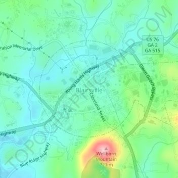
Nom : Carte topographique Blairsville, altitude, relief.
Lieu : Blairsville, Union County, Georgia, United States (34.86877 -83.96754 34.88341 -83.93990)
Altitude moyenne : 587 m
Altitude minimum : 542 m
Altitude maximum : 726 m
Blairsville has a humid subtropical climate, yet due to its elevation of 1,883 feet (574 m), typically records far lower temperatures at night than what is encountered in much of the Southeastern U.S., and has slightly higher precipitation totals (56 inches or 1,420 millimetres annually) than most locations in the state; the average diurnal temperature variation exceeds 25 °F (14 °C) in each of the spring and autumn months. Snow usually occurs several times every year. The average annual snowfall is 4 inches. The monthly daily mean temperature ranges from 36.8 °F (2.7 °C) in January to 73.3 °F (22.9 °C) in July. There are 7.6 days of 90 °F (32 °C) highs and 4.6 days where the high fails to rise above freezing annually.
Autres cartes topographiques
Cliquez sur une carte pour visualiser sa topographie, son altitude et son relief.
Owltown
United States > Georgia > Union County
Owltown, Union County, Georgia, United States
Altitude moyenne : 678 m
Suches
United States > Georgia > Union County
Suches, Union County, Georgia, United States
Altitude moyenne : 871 m