
Carte topographique Faßberg
Carte interactive
Cliquez sur la carte pour afficher l’altitude.
À propos de cette carte
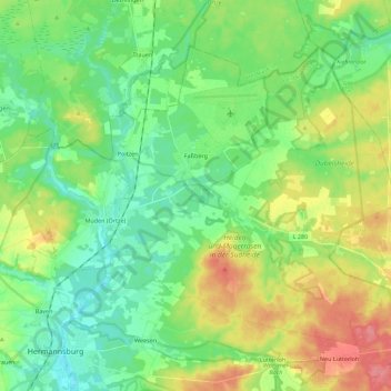
Nom : Carte topographique Faßberg, altitude, relief.
Lieu : Faßberg, Landkreis Celle, Lower Saxony, 29328, Germany (52.83355 10.05849 52.93660 10.28112)
Altitude moyenne : 77 m
Altitude minimum : 50 m
Altitude maximum : 128 m
Autres cartes topographiques
Cliquez sur une carte pour visualiser sa topographie, son altitude et son relief.
Celle
Germany > Lower Saxony > Landkreis Celle
Celle, Landkreis Celle, Lower Saxony, Germany
Altitude moyenne : 48 m
Wathlingen
Germany > Lower Saxony > Landkreis Celle
Wathlingen, Samtgemeinde Wathlingen, Landkreis Celle, Lower Saxony, 29339, Germany
Altitude moyenne : 44 m
Lohheide
Germany > Lower Saxony > Landkreis Celle > Lohheide
Lohheide, Landkreis Celle, Lower Saxony, Germany
Altitude moyenne : 71 m
Klein Hehlen
Germany > Lower Saxony > Landkreis Celle > Celle
Klein Hehlen, Celle, Landkreis Celle, Lower Saxony, Germany
Altitude moyenne : 42 m