
Carte topographique Nubra
Carte interactive
Cliquez sur la carte pour afficher l’altitude.
À propos de cette carte
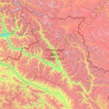
Nom : Carte topographique Nubra, altitude, relief.
Lieu : Nubra, Leh District, Ladakh, 194401, Inde (33.97611 76.66317 35.67455 79.04537)
Altitude moyenne : 4 978 m
Altitude minimum : 2 471 m
Altitude maximum : 7 793 m
La rivière Shyok rencontre la rivière Noubra (ou rivière Siachan) pour former une grande vallée qui sépare les chaînes du Ladakh et du Karakoram. La rivière Shyok est un affluent de la rivière Indus. L'altitude moyenne de la vallée est de plus de 3 000 m. Le moyen commun d'accéder à cette vallée est le col de Khardung La depuis Leh. Les ressortissants étrangers doivent obtenir un permis d'aire protégée pour visiter Noubra.
Autres cartes topographiques
Cliquez sur une carte pour visualiser sa topographie, son altitude et son relief.
Namche
Inde > Ladakh > Kargil tehsil
Namche, Kargil tehsil, Kargil District, Ladakh, Inde
Altitude moyenne : 3 861 m
Hemis
Inde > Ladakh > Leh tehsil
Hemis, Leh Tehsil, Leh District, Ladakh, Inde
Altitude moyenne : 5 218 m
Zanskar
Inde > Ladakh > Zanskar tehsil
Zanskar, Zanskar tehsil, Kargil District, Ladakh, Inde
Altitude moyenne : 4 285 m
Phyang
Inde > Ladakh > Leh tehsil
Phyang, Leh Tehsil, Leh District, Ladakh, 194101, Inde
Altitude moyenne : 3 742 m
Shey
Inde > Ladakh > Leh tehsil
Shey, Leh Tehsil, Leh District, Ladakh, Inde
Altitude moyenne : 3 282 m
Kang Yatse II
Inde > Ladakh > Leh tehsil
Kang Yatse II, Leh Tehsil, Leh District, Ladakh, Inde
Altitude moyenne : 5 688 m
Kargyak
Inde > Ladakh > Zanskar tehsil
Kargyak, Zanskar tehsil, Kargil District, Ladakh, Inde
Altitude moyenne : 4 362 m
Stongde
Inde > Ladakh > Zanskar tehsil
Stongde, Zanskar tehsil, Kargil District, Ladakh, Inde
Altitude moyenne : 3 687 m
Ursi
Inde > Ladakh > Khalsi tehsil
Ursi, Khalsi tehsil, Leh District, Ladakh, Inde
Altitude moyenne : 3 941 m
Purne
Inde > Ladakh > Zanskar tehsil
Purne, Zanskar tehsil, Kargil District, Ladakh, Inde
Altitude moyenne : 4 029 m
Lingshed
Inde > Ladakh > Khalsi tehsil
Lingshed, Khalsi tehsil, Leh District, Ladakh, Inde
Altitude moyenne : 4 209 m
Tiger Hill, Kargil
Inde > Ladakh > Kargil tehsil
Tiger Hill, Kargil, Kargil tehsil, Kargil District, Ladakh, Inde
Altitude moyenne : 4 537 m
Uleytokpo
Inde > Ladakh > Khalsi tehsil
Uleytokpo, Khalsi tehsil, Leh District, Ladakh, Inde
Altitude moyenne : 3 361 m
Thiksey
Inde > Ladakh > Leh tehsil
Thiksey, Leh Tehsil, Leh District, Ladakh, 194201, Inde
Altitude moyenne : 3 304 m
Miru
Inde > Ladakh > Leh tehsil
Miru, Leh Tehsil, Leh District, Ladakh, Inde
Altitude moyenne : 3 949 m
Sasoma
Inde > Ladakh > Leh tehsil
Sasoma, Leh Tehsil, Leh District, Ladakh, Inde
Altitude moyenne : 4 287 m
Nyoma
Inde > Ladakh > Leh tehsil
Nyoma, Leh Tehsil, Leh District, Ladakh, 194404, Inde
Altitude moyenne : 4 260 m
Yugar
Inde > Ladakh > Zanskar tehsil
Yugar, Zanskar tehsil, Kargil district, Ladakh, Inde
Altitude moyenne : 4 223 m
Khaltse
Inde > Ladakh > Khalsi tehsil
Khaltse, Khalsi tehsil, Leh District, Ladakh, Inde
Altitude moyenne : 3 287 m
Tso Kar
Inde > Ladakh > Leh tehsil
Tso Kar, Leh Tehsil, Leh District, Ladakh, Inde
Altitude moyenne : 4 618 m
Tso Moriri
Inde > Ladakh > Leh tehsil > Karzok
Tso Moriri, Karzok, Leh Tehsil, Leh District, Ladakh, Inde
Altitude moyenne : 5 044 m
Skyu
Inde > Ladakh > Leh tehsil > Kaya
Skyu, Kaya, Leh Tehsil, Leh District, Ladakh, Inde
Altitude moyenne : 3 785 m
Nurnis
Inde > Ladakh > Leh tehsil
Nurnis, Leh Tehsil, Leh District, Ladakh, Inde
Altitude moyenne : 4 292 m
Ichar
Inde > Ladakh > Zanskar tehsil
Ichar, Zanskar tehsil, Kargil district, Ladakh, Inde
Altitude moyenne : 4 131 m
Padum
Inde > Ladakh > Zanskar tehsil
Padum, Zanskar tehsil, Kargil district, Ladakh, 194302, Inde
Altitude moyenne : 3 632 m
Zanskar tehsil
Zanskar tehsil, Kargil district, Ladakh, 194302, Inde
Altitude moyenne : 4 764 m
Nangma
Inde > Ladakh > Leh tehsil
Nangma, Leh Tehsil, Leh District, Ladakh, Inde
Altitude moyenne : 5 247 m
Tetleh Kangri
Inde > Ladakh > Zanskar tehsil
Tetleh Kangri, Zanskar tehsil, Kargil district, Ladakh, Inde
Altitude moyenne : 5 517 m
Remalaye (H5 - Sakamoto)
Inde > Ladakh > Zanskar tehsil
Remalaye (H5 - Sakamoto), Zanskar tehsil, Kargil district, Ladakh, Inde
Altitude moyenne : 5 542 m
Zangla
Inde > Ladakh > Zanskar tehsil
Zangla, Zanskar tehsil, Kargil district, Ladakh, Inde
Altitude moyenne : 3 766 m
Rangdum
Inde > Ladakh > Sankoo tehsil
Rangdum, Sankoo tehsil, Kargil District, Ladakh, Inde
Altitude moyenne : 4 128 m
Siachen Glacier
Siachen Glacier, Nubra, Leh District, Ladakh, Inde
Altitude moyenne : 5 448 m
Kargil
Inde > Ladakh > Kargil tehsil
Kargil, Kargil tehsil, Kargil district, Ladakh, 194103, Inde
Altitude moyenne : 3 261 m
Kargil tehsil
Inde > Ladakh > Kargil tehsil
Kargil tehsil, Kargil district, Ladakh, 194103, Inde
Altitude moyenne : 4 005 m
Hanle
Inde > Ladakh > Leh tehsil
Hanle, Leh Tehsil, Leh District, Ladakh, Inde
Altitude moyenne : 4 287 m
Karzok
Inde > Ladakh > Leh tehsil
Karzok, Leh Tehsil, Leh District, Ladakh, Inde
Altitude moyenne : 4 618 m
Lamayuru
Inde > Ladakh > Khalsi tehsil
Lamayuru, Khalsi tehsil, Leh District, Ladakh, Inde
Altitude moyenne : 3 691 m