
Carte topographique Lowick
Cliquez sur la carte pour afficher l’altitude.
À propos de cette carte
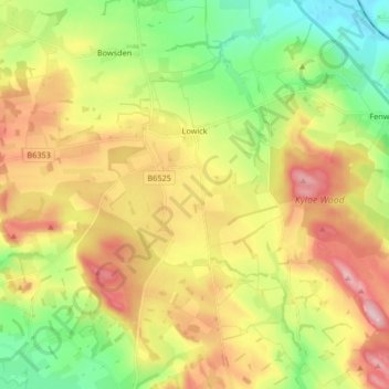
Nom : Carte topographique Lowick, altitude, relief.
Lieu : Lowick, Northumberland, North East, England, United Kingdom (55.59953 -2.06104 55.67108 -1.89503)
Altitude moyenne : 93 m
Altitude minimum : 2 m
Altitude maximum : 205 m
Autres cartes topographiques
Cliquez sur une carte pour visualiser sa topographie, son altitude et son relief.
Catcleugh Reservoir
United Kingdom > England > Northumberland
Catcleugh Reservoir is a reservoir in Northumberland, England, adjacent to the A68 road just north of Byrness and to the southeast of the border with Scotland. It has a surface area of 98.654 ha and a mean depth of 9.8 m, a catchment area of 4007.5 ha, and is situated at 247 m altitude.
Altitude moyenne : 316 m
Amble
United Kingdom > England > Northumberland
Samuel Lewis reported a township population of 247 in 1831. By the seventh edition of his Topographical Dictionary of England, which was published in 1848, this figure had risen to 724. The population was reported as being 1,040 in 1851. The 1871 census recorded a population of 1,233, spread among 233 houses.
Altitude moyenne : 15 m
Sharp Law
United Kingdom > England > Northumberland > Crookham > Crookham Eastfield
Altitude moyenne : 56 m
Berwick
United Kingdom > England > Northumberland > Berwick-upon-Tweed > Spittal
Altitude moyenne : 8 m
North Hazelrigg
United Kingdom > England > Northumberland > Chatton > North Hazelrigg
Altitude moyenne : 99 m
Twizel Smithy
United Kingdom > England > Northumberland > Duddo > Twizel Smithy
Altitude moyenne : 40 m