
Carte topographique Steeton with Eastburn
Carte interactive
Cliquez sur la carte pour afficher l’altitude.
À propos de cette carte
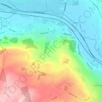
Nom : Carte topographique Steeton with Eastburn, altitude, relief.
Altitude moyenne : 182 m
Altitude minimum : 84 m
Altitude maximum : 352 m
Autres cartes topographiques
Cliquez sur une carte pour visualiser sa topographie, son altitude et son relief.
Ilkley
United Kingdom > England > Bradford
Ilkley, Bradford, West Yorkshire, England, United Kingdom
Altitude moyenne : 221 m
Bingley
United Kingdom > England > Bradford
Bingley, Bradford, West Yorkshire, England, United Kingdom
Altitude moyenne : 198 m
Baildon
United Kingdom > England > Bradford > Baildon
Baildon, Bradford, West Yorkshire, England, United Kingdom
Altitude moyenne : 147 m
Middle Brook
United Kingdom > England > Bradford
Middle Brook, Bradford, Yorkshire and the Humber, England, BD8 0ES, United Kingdom
Altitude moyenne : 170 m