
Carte topographique La Grotte Dagobert
Carte interactive
Cliquez sur la carte pour afficher l’altitude.
À propos de cette carte
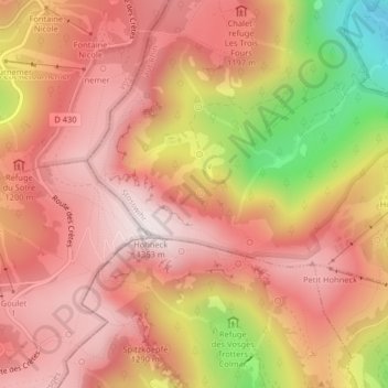
Nom : Carte topographique La Grotte Dagobert, altitude, relief.
Altitude moyenne : 1 121 m
Altitude minimum : 660 m
Altitude maximum : 1 352 m
Autres cartes topographiques
Cliquez sur une carte pour visualiser sa topographie, son altitude et son relief.
Réserve naturelle du Frankenthal-Missheimle
France > Grand Est > Stosswihr
Réserve naturelle du Frankenthal-Missheimle, Sentier de la Bloy, Stosswihr, Colmar-Ribeauvillé, Haut-Rhin, Grand Est, France métropolitaine, 68140, France
Altitude moyenne : 1 003 m
Lac de Schiessrothried
France > Grand Est > Stosswihr
Lac de Schiessrothried, Sentier des Couloirs, Stosswihr, Colmar-Ribeauvillé, Haut-Rhin, Grand Est, France métropolitaine, 68140, France
Altitude moyenne : 1 074 m
Petit Cervin
France > Grand Est > Stosswihr
Petit Cervin, Sentier du Falimont, Stosswihr, Colmar-Ribeauvillé, Haut-Rhin, Grand Est, France métropolitaine, 68140, France
Altitude moyenne : 1 131 m