
Carte topographique Thunderbolt
Carte interactive
Cliquez sur la carte pour afficher l’altitude.
À propos de cette carte
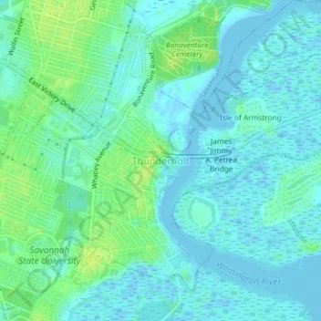
Nom : Carte topographique Thunderbolt, altitude, relief.
Lieu : Thunderbolt, Chatham County, Georgia, United States (32.02093 -81.06394 32.04606 -81.02741)
Altitude moyenne : 5 m
Altitude minimum : -4 m
Altitude maximum : 14 m
Autres cartes topographiques
Cliquez sur une carte pour visualiser sa topographie, son altitude et son relief.
Savannah
United States > Georgia > Chatham County
Savannah, Chatham County, Georgia, United States
Altitude moyenne : 4 m
Oakdale
United States > Georgia > Chatham County > Savannah
Oakdale, Savannah, Chatham County, Georgia, 31406, United States
Altitude moyenne : 10 m
Welwood
United States > Georgia > Chatham County > Savannah
Welwood, Savannah, Chatham County, Georgia, 31409, United States
Altitude moyenne : 7 m
Tybee Island
United States > Georgia > Chatham County
Tybee Island, Chatham County, Georgia, 31328, United States
Altitude moyenne : 1 m
O'Leary
United States > Georgia > Chatham County > Port Wentworth > O'Leary
O'Leary, Port Wentworth, Chatham County, Georgia, 31407, United States
Altitude moyenne : 5 m