
Merci de soutenir ce site ❤️
Faire un don
Faire un don
Équipez-vous pour votre prochaine aventure :
En tant que Partenaire Amazon, ce site perçoit une commission sur les achats éligibles sans surcoût pour vous.
Carte topographique Lac Tarse
Cliquez sur la carte pour afficher l’altitude.
Merci de soutenir ce site ❤️
Faire un don
Faire un don
Équipez-vous pour votre prochaine aventure :
En tant que Partenaire Amazon, ce site perçoit une commission sur les achats éligibles sans surcoût pour vous.
À propos de cette carte
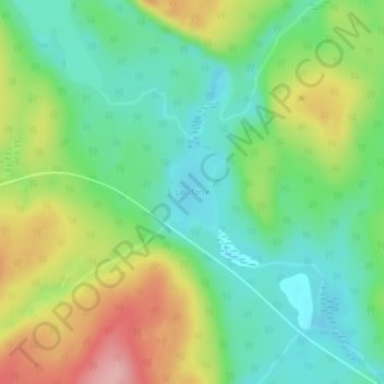
Nom : Carte topographique Lac Tarse, altitude, relief.
Altitude moyenne : 279 m
Altitude minimum : 225 m
Altitude maximum : 371 m
Merci de soutenir ce site ❤️
Faire un don
Faire un don
Équipez-vous pour votre prochaine aventure :
En tant que Partenaire Amazon, ce site perçoit une commission sur les achats éligibles sans surcoût pour vous.
Autres cartes topographiques
Cliquez sur une carte pour visualiser sa topographie, son altitude et son relief.