
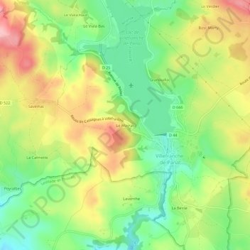
Carte topographique Le Mayrac
Carte interactive
Cliquez sur la carte pour afficher l’altitude.
À propos de cette carte
Nom : Carte topographique Le Mayrac, altitude, relief.
Altitude moyenne : 763 m
Altitude minimum : 691 m
Altitude maximum : 852 m
Autres cartes topographiques
Cliquez sur une carte pour visualiser sa topographie, son altitude et son relief.
Lac de Villefranche-de-Panat
France > Occitanie > Aveyron > Villefranche-de-Panat
Lac de Villefranche-de-Panat, Villefranche-de-Panat, Millau, Aveyron, Occitanie, France métropolitaine, 12430, France
Altitude moyenne : 761 m
La Fumadette
France > Occitanie > Aveyron > Villefranche-de-Panat > La Fumadette
La Fumadette, Villefranche-de-Panat, Millau, Aveyron, Occitanie, France métropolitaine, 12430, France
Altitude moyenne : 656 m