
Carte topographique White Lakes
Carte interactive
Cliquez sur la carte pour afficher l’altitude.
À propos de cette carte
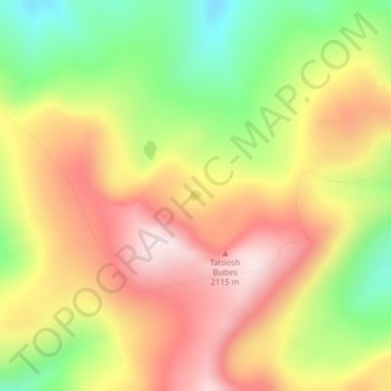
Nom : Carte topographique White Lakes, altitude, relief.
Lieu : White Lakes, Okanogan County, Washington, United States (48.90544 -120.54543 48.90619 -120.54420)
Altitude moyenne : 1 979 m
Altitude minimum : 1 722 m
Altitude maximum : 2 208 m
Autres cartes topographiques
Cliquez sur une carte pour visualiser sa topographie, son altitude et son relief.
Washburn Island
United States > Washington > Okanogan County
Washburn Island, Okanogan County, Washington, United States
Altitude moyenne : 271 m
Brown Lake
United States > Washington > Okanogan County > Brown Lake
Brown Lake, Okanogan County, Okanogan, Washington, United States
Altitude moyenne : 719 m