
Faire un don
Équipez-vous pour votre prochaine aventure :
En tant que Partenaire Amazon, ce site perçoit une commission sur les achats éligibles sans surcoût pour vous.
Carte topographique Ratby
Cliquez sur la carte pour afficher l’altitude.
Faire un don
Équipez-vous pour votre prochaine aventure :
En tant que Partenaire Amazon, ce site perçoit une commission sur les achats éligibles sans surcoût pour vous.
À propos de cette carte
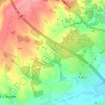
Nom : Carte topographique Ratby, altitude, relief.
Altitude moyenne : 118 m
Altitude minimum : 74 m
Altitude maximum : 168 m
Faire un don
Équipez-vous pour votre prochaine aventure :
En tant que Partenaire Amazon, ce site perçoit une commission sur les achats éligibles sans surcoût pour vous.
Autres cartes topographiques
Cliquez sur une carte pour visualiser sa topographie, son altitude et son relief.
Market Bosworth Country Park
United Kingdom > England > Leicestershire > Hinckley and Bosworth > Market Bosworth
Altitude moyenne : 119 m
Faire un don
Équipez-vous pour votre prochaine aventure :
En tant que Partenaire Amazon, ce site perçoit une commission sur les achats éligibles sans surcoût pour vous.
Ratcliffe Culey
United Kingdom > England > Leicestershire > Hinckley and Bosworth
Altitude moyenne : 77 m
Stretton Baskerville
United Kingdom > England > Leicestershire > Hinckley and Bosworth
Altitude moyenne : 111 m
Fenny Drayton
United Kingdom > England > Leicestershire > Hinckley and Bosworth
Altitude moyenne : 86 m
Faire un don
Équipez-vous pour votre prochaine aventure :
En tant que Partenaire Amazon, ce site perçoit une commission sur les achats éligibles sans surcoût pour vous.
Barton in the Beans
United Kingdom > England > Leicestershire > Hinckley and Bosworth
Altitude moyenne : 113 m
Higham on the Hill
United Kingdom > England > Leicestershire > Hinckley and Bosworth
Altitude moyenne : 96 m
Merry Lees
United Kingdom > England > Leicestershire > Hinckley and Bosworth > Botcheston
Altitude moyenne : 126 m
Faire un don
Équipez-vous pour votre prochaine aventure :
En tant que Partenaire Amazon, ce site perçoit une commission sur les achats éligibles sans surcoût pour vous.
Kirkby Mallory
United Kingdom > England > Leicestershire > Hinckley and Bosworth
Altitude moyenne : 115 m
Faire un don
Équipez-vous pour votre prochaine aventure :
En tant que Partenaire Amazon, ce site perçoit une commission sur les achats éligibles sans surcoût pour vous.
Billa Barra Hill
United Kingdom > England > Leicestershire > Hinckley and Bosworth > Stanton under Bardon
Altitude moyenne : 191 m
Faire un don
Équipez-vous pour votre prochaine aventure :
En tant que Partenaire Amazon, ce site perçoit une commission sur les achats éligibles sans surcoût pour vous.
Burroughs Wood
United Kingdom > England > Leicestershire > Hinckley and Bosworth > Botcheston
Altitude moyenne : 114 m
Sheepy Magna
United Kingdom > England > Leicestershire > Hinckley and Bosworth
Altitude moyenne : 82 m
Faire un don
Équipez-vous pour votre prochaine aventure :
En tant que Partenaire Amazon, ce site perçoit une commission sur les achats éligibles sans surcoût pour vous.
Stanton under Bardon
United Kingdom > England > Leicestershire > Hinckley and Bosworth
Altitude moyenne : 176 m
Stretton Baskerville
United Kingdom > England > Leicestershire > Hinckley and Bosworth
Altitude moyenne : 111 m
Kirkby Mallory
United Kingdom > England > Leicestershire > Hinckley and Bosworth
Altitude moyenne : 115 m
Faire un don
Équipez-vous pour votre prochaine aventure :
En tant que Partenaire Amazon, ce site perçoit une commission sur les achats éligibles sans surcoût pour vous.