
Carte topographique Grybów
Carte interactive
Cliquez sur la carte pour afficher l’altitude.
À propos de cette carte
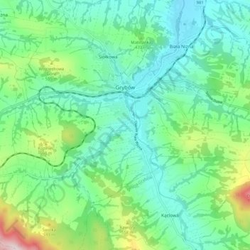
Nom : Carte topographique Grybów, altitude, relief.
Lieu : Grybów, Nowy Sącz County, Lesser Poland Voivodeship, Poland (49.59407 20.90548 49.63580 21.00910)
Altitude moyenne : 433 m
Altitude minimum : 304 m
Altitude maximum : 826 m
Grybów [ˈɡrɨbuf] (Ukrainian: Грибів, Hrybiv; German: Grünberg, Grynberk; Yiddish: גריבאוו, Gribuv), is a town in the Nowy Sącz County, in Lesser Poland Voivodeship of Poland, with 12,409 inhabitants (2005). It is located in the heartland of the Doły Jasielsko Sanockie (Doły Pits), and its average altitude is 370 metres above sea level, although there are some hills located within the confines of the city, Grybów has the steepest town square in medieval Europe.