
Carte topographique Narok
Carte interactive
Cliquez sur la carte pour afficher l’altitude.
À propos de cette carte
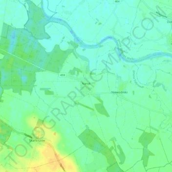
Nom : Carte topographique Narok, altitude, relief.
Lieu : Narok, gmina Dąbrowa, Opole County, Opole Voivodeship, Poland (50.70939 17.73250 50.77636 17.82571)
Altitude moyenne : 149 m
Altitude minimum : 141 m
Altitude maximum : 166 m
Narok (sometimes referred to as Narok Town) is a town west of Nairobi that supports Kenya's economy in south-west of the country, along the Great Rift Valley. Narok is the district capital of the Narok County and stands as the major centre of commerce in the district. Narok has a population of around 40,000 people, mostly Maasai. The elevation of Narok is 1827 metres (5,997 feet) in altitude.
Autres cartes topographiques
Cliquez sur une carte pour visualiser sa topographie, son altitude et son relief.
Krasiejów
Poland > Opole Voivodeship > Opole County > Krasiejów
Krasiejów, gmina Ozimek, Opole County, Opole Voivodeship, Poland
Altitude moyenne : 189 m