
Carte topographique Nizhny Novgorod
Carte interactive
Cliquez sur la carte pour afficher l’altitude.
À propos de cette carte
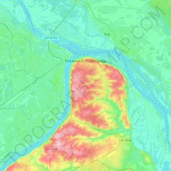
Nom : Carte topographique Nizhny Novgorod, altitude, relief.
Altitude moyenne : 93 m
Altitude minimum : 59 m
Altitude maximum : 209 m
Originally the name was just Novgorod ("Newtown"), but to distinguish it from the other, older and well-known Novgorod (Veliky Novgorod) to the west, the city was commonly called "Novgorod of the Lower lands," or "Lower Newtown." This land was named "lower" (nizhniy (нижний)), even though it is actually higher in altitude than Veliky Novgorod, because it is situated downstream of other Russian cities such as Moscow, Vladimir and Murom.
Autres cartes topographiques
Cliquez sur une carte pour visualiser sa topographie, son altitude et son relief.
Стрелка
Russia > Nizhny Novgorod Oblast > Nizhny Novgorod > Nizhny Novgorod
Стрелка, Канавинский район, Nizhny Novgorod, Nizhny Novgorod Oblast, Volga Federal District, 603086, Russia
Altitude moyenne : 76 m
Nizhny Novgorod
Russia > Nizhny Novgorod Oblast > Nizhny Novgorod > Nizhny Novgorod
Nizhny Novgorod, Nizhny Novgorod Oblast, Volga Federal District, 603082, Russia
Altitude moyenne : 87 m