
Carte topographique Interlochen
Carte interactive
Cliquez sur la carte pour afficher l’altitude.
À propos de cette carte
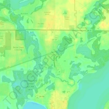
Nom : Carte topographique Interlochen, altitude, relief.
Altitude moyenne : 257 m
Altitude minimum : 247 m
Altitude maximum : 269 m
Autres cartes topographiques
Cliquez sur une carte pour visualiser sa topographie, son altitude et son relief.
Grand Traverse Bay
United States > Michigan > Grand Traverse County
Grand Traverse Bay, Grand Traverse County, Michigan, 49682, United States
Altitude moyenne : 201 m
Williamsburg
United States > Michigan > Grand Traverse County
Williamsburg, Whitewater Township, Grand Traverse County, Michigan, 49690, United States
Altitude moyenne : 228 m
East Bay Township
United States > Michigan > Grand Traverse County
East Bay Township, Grand Traverse County, Michigan, United States
Altitude moyenne : 252 m
Traverse City
United States > Michigan > Grand Traverse County
Traverse City, Grand Traverse County, Michigan, United States
Altitude moyenne : 204 m