
Carte topographique Rinkerode
Carte interactive
Cliquez sur la carte pour afficher l’altitude.
À propos de cette carte
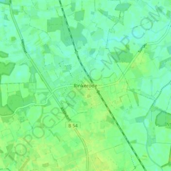
Nom : Carte topographique Rinkerode, altitude, relief.
Altitude moyenne : 60 m
Altitude minimum : 54 m
Altitude maximum : 65 m
Autres cartes topographiques
Cliquez sur une carte pour visualiser sa topographie, son altitude et son relief.
Haus Heidhorn
Deutschland > Nordrhein-Westfalen > Kreis Warendorf > Drensteinfurt
Haus Heidhorn, Münster-Hiltrup, Drensteinfurt, Kreis Warendorf, Nordrhein-Westfalen, 48163, Deutschland
Altitude moyenne : 59 m