
Faire un don
Équipez-vous pour votre prochaine aventure :
En tant que Partenaire Amazon, ce site perçoit une commission sur les achats éligibles sans surcoût pour vous.
Carte topographique Vyas (Damauli)
Cliquez sur la carte pour afficher l’altitude.
Faire un don
Équipez-vous pour votre prochaine aventure :
En tant que Partenaire Amazon, ce site perçoit une commission sur les achats éligibles sans surcoût pour vous.
À propos de cette carte
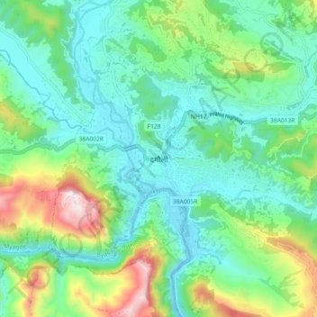
Nom : Carte topographique Vyas (Damauli), altitude, relief.
Lieu : Vyas (Damauli), Byas, Tanahun, Gandaki Province, Nepal (27.93671 84.22935 28.01671 84.30935)
Altitude moyenne : 502 m
Altitude minimum : 294 m
Altitude maximum : 1 079 m
Faire un don
Équipez-vous pour votre prochaine aventure :
En tant que Partenaire Amazon, ce site perçoit une commission sur les achats éligibles sans surcoût pour vous.
Autres cartes topographiques
Cliquez sur une carte pour visualiser sa topographie, son altitude et son relief.
Bandipur
Nepal > Gandaki Province > Tanahun
Bandipur is located at 27.56 N, 84.25 E and an elevation of 1030m on a mountain saddle (Mahabharat range) approximately 700m above the Marsyangdi River Valley, 143 km to the west of Kathmandu and 80 km to the east of Pokhara. Since 1998 it is connected by an 8 km access road from Dumre (Prithvi Highway). Until…
Altitude moyenne : 719 m
Faire un don
Équipez-vous pour votre prochaine aventure :
En tant que Partenaire Amazon, ce site perçoit une commission sur les achats éligibles sans surcoût pour vous.
Bandipur
Nepal > Gandaki Province > Tanahun
Bandipur is located at 27.56 N, 84.25 E and an elevation of 1030m on a mountain saddle (Mahabharat range) approximately 700m above the Marsyangdi River Valley, 143 km to the west of Kathmandu and 80 km to the east of Pokhara. Since 1998 it is connected by an 8 km access road from Dumre (Prithvi Highway). Until…
Altitude moyenne : 719 m