
Carte topographique Sunningdale
Carte interactive
Cliquez sur la carte pour afficher l’altitude.
À propos de cette carte
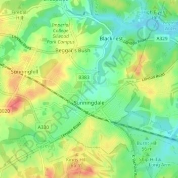
Nom : Carte topographique Sunningdale, altitude, relief.
Altitude moyenne : 61 m
Altitude minimum : 37 m
Altitude maximum : 97 m
Autres cartes topographiques
Cliquez sur une carte pour visualiser sa topographie, son altitude et son relief.
Maidenhead
United Kingdom > England > Royal Borough of Windsor and Maidenhead
Maidenhead, Royal Borough of Windsor and Maidenhead, England, SL6 1QB, United Kingdom
Altitude moyenne : 41 m
Clewer Village
United Kingdom > England > Royal Borough of Windsor and Maidenhead > Windsor
Clewer Village, Windsor, Royal Borough of Windsor and Maidenhead, England, SL4 5JG, United Kingdom
Altitude moyenne : 26 m
Eton
United Kingdom > England > Royal Borough of Windsor and Maidenhead
Eton, Royal Borough of Windsor and Maidenhead, England, United Kingdom
Altitude moyenne : 23 m
Fifield
United Kingdom > England > Royal Borough of Windsor and Maidenhead
Fifield, Bray, Royal Borough of Windsor and Maidenhead, England, SL6 2PB, United Kingdom
Altitude moyenne : 33 m
Ascot
United Kingdom > England > Royal Borough of Windsor and Maidenhead
Ascot, Royal Borough of Windsor and Maidenhead, England, SL5 7FW, United Kingdom
Altitude moyenne : 72 m