
Faire un don
Équipez-vous pour votre prochaine aventure :
En tant que Partenaire Amazon, ce site perçoit une commission sur les achats éligibles sans surcoût pour vous.
Carte topographique Bagthorpe
Cliquez sur la carte pour afficher l’altitude.
Faire un don
Équipez-vous pour votre prochaine aventure :
En tant que Partenaire Amazon, ce site perçoit une commission sur les achats éligibles sans surcoût pour vous.
À propos de cette carte
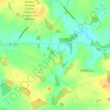
Nom : Carte topographique Bagthorpe, altitude, relief.
Altitude moyenne : 63 m
Altitude minimum : 49 m
Altitude maximum : 81 m
Faire un don
Équipez-vous pour votre prochaine aventure :
En tant que Partenaire Amazon, ce site perçoit une commission sur les achats éligibles sans surcoût pour vous.
Autres cartes topographiques
Cliquez sur une carte pour visualiser sa topographie, son altitude et son relief.
Ringstead
United Kingdom > England > Norfolk > King's Lynn and West Norfolk > Ringstead
Altitude moyenne : 37 m
Faire un don
Équipez-vous pour votre prochaine aventure :
En tant que Partenaire Amazon, ce site perçoit une commission sur les achats éligibles sans surcoût pour vous.
Grimston
United Kingdom > England > Norfolk > King's Lynn and West Norfolk > Grimston
Altitude moyenne : 30 m
Downham Market
United Kingdom > England > Norfolk > King's Lynn and West Norfolk
Altitude moyenne : 20 m
Faire un don
Équipez-vous pour votre prochaine aventure :
En tant que Partenaire Amazon, ce site perçoit une commission sur les achats éligibles sans surcoût pour vous.
Terrington St. Clement
United Kingdom > England > Norfolk > King's Lynn and West Norfolk
Altitude moyenne : 2 m
Faire un don
Équipez-vous pour votre prochaine aventure :
En tant que Partenaire Amazon, ce site perçoit une commission sur les achats éligibles sans surcoût pour vous.
Old Hunstanton
United Kingdom > England > Norfolk > King's Lynn and West Norfolk
Altitude moyenne : 17 m
Faire un don
Équipez-vous pour votre prochaine aventure :
En tant que Partenaire Amazon, ce site perçoit une commission sur les achats éligibles sans surcoût pour vous.
Holme next the Sea
United Kingdom > England > Norfolk > King's Lynn and West Norfolk
Altitude moyenne : 10 m
Tilney All Saints
United Kingdom > England > Norfolk > King's Lynn and West Norfolk
Altitude moyenne : 3 m
South Creake
United Kingdom > England > Norfolk > King's Lynn and West Norfolk
Altitude moyenne : 54 m
Faire un don
Équipez-vous pour votre prochaine aventure :
En tant que Partenaire Amazon, ce site perçoit une commission sur les achats éligibles sans surcoût pour vous.
North Creake
United Kingdom > England > Norfolk > King's Lynn and West Norfolk
Altitude moyenne : 46 m
Faire un don
Équipez-vous pour votre prochaine aventure :
En tant que Partenaire Amazon, ce site perçoit une commission sur les achats éligibles sans surcoût pour vous.
Little Massingham
United Kingdom > England > Norfolk > King's Lynn and West Norfolk
Altitude moyenne : 74 m
Syderstone
United Kingdom > England > Norfolk > King's Lynn and West Norfolk > Syderstone
Altitude moyenne : 60 m
Faire un don
Équipez-vous pour votre prochaine aventure :
En tant que Partenaire Amazon, ce site perçoit une commission sur les achats éligibles sans surcoût pour vous.
Hockwold cum Wilton
United Kingdom > England > Norfolk > King's Lynn and West Norfolk
Altitude moyenne : 11 m
Tilney St. Lawrence
United Kingdom > England > Norfolk > King's Lynn and West Norfolk
Altitude moyenne : 2 m
Faire un don
Équipez-vous pour votre prochaine aventure :
En tant que Partenaire Amazon, ce site perçoit une commission sur les achats éligibles sans surcoût pour vous.
Great Massingham
United Kingdom > England > Norfolk > King's Lynn and West Norfolk
Altitude moyenne : 79 m
Ingoldisthorpe
United Kingdom > England > Norfolk > King's Lynn and West Norfolk
Altitude moyenne : 22 m
Faire un don
Équipez-vous pour votre prochaine aventure :
En tant que Partenaire Amazon, ce site perçoit une commission sur les achats éligibles sans surcoût pour vous.
Hunstanton Beach
United Kingdom > England > Norfolk > King's Lynn and West Norfolk > Hunstanton > Old Hunstanton
Altitude moyenne : 10 m
Castle Rising
United Kingdom > England > Norfolk > King's Lynn and West Norfolk
Altitude moyenne : 20 m
Faire un don
Équipez-vous pour votre prochaine aventure :
En tant que Partenaire Amazon, ce site perçoit une commission sur les achats éligibles sans surcoût pour vous.
Roydon
United Kingdom > England > Norfolk > King's Lynn and West Norfolk > Roydon
Altitude moyenne : 20 m
Ely-Ouse-Essex Water Transfer Scheme
United Kingdom > England > Norfolk > King's Lynn and West Norfolk > Hockwold cum Wilton
Altitude moyenne : 4 m
Burnham Overy
United Kingdom > England > Norfolk > King's Lynn and West Norfolk
Altitude moyenne : 6 m
Faire un don
Équipez-vous pour votre prochaine aventure :
En tant que Partenaire Amazon, ce site perçoit une commission sur les achats éligibles sans surcoût pour vous.
Northwold
United Kingdom > England > Norfolk > King's Lynn and West Norfolk > Northwold
Altitude moyenne : 12 m
Sandringham Estate
United Kingdom > England > Norfolk > King's Lynn and West Norfolk > Sandringham
Altitude moyenne : 25 m
Walpole Highway
United Kingdom > England > Norfolk > King's Lynn and West Norfolk > Walpole Highway
Altitude moyenne : 2 m
Faire un don
Équipez-vous pour votre prochaine aventure :
En tant que Partenaire Amazon, ce site perçoit une commission sur les achats éligibles sans surcoût pour vous.
Ryston
United Kingdom > England > Norfolk > King's Lynn and West Norfolk > Fordham
Altitude moyenne : 15 m
Clenchwarton
United Kingdom > England > Norfolk > King's Lynn and West Norfolk > Clenchwarton
Altitude moyenne : 3 m
Faire un don
Équipez-vous pour votre prochaine aventure :
En tant que Partenaire Amazon, ce site perçoit une commission sur les achats éligibles sans surcoût pour vous.
Bawsey
United Kingdom > England > Norfolk > King's Lynn and West Norfolk > Bawsey
Altitude moyenne : 16 m
Burnham Market
United Kingdom > England > Norfolk > King's Lynn and West Norfolk
Altitude moyenne : 44 m
Faire un don
Équipez-vous pour votre prochaine aventure :
En tant que Partenaire Amazon, ce site perçoit une commission sur les achats éligibles sans surcoût pour vous.
Terrington St. John
United Kingdom > England > Norfolk > King's Lynn and West Norfolk
Altitude moyenne : 2 m
Docking
United Kingdom > England > Norfolk > King's Lynn and West Norfolk
Docking village in the centre of the parish is situated at an elevation of 82.7 metres (272 feet), which makes it one of the highest in Norfolk. It is surrounded by arable farmland having little woodland and is a nucleated settlement, with only one historical hamlet associated with it. This is Summerfield to…
Altitude moyenne : 63 m
Faire un don
Équipez-vous pour votre prochaine aventure :
En tant que Partenaire Amazon, ce site perçoit une commission sur les achats éligibles sans surcoût pour vous.
Wiggenhall St. Mary Magdalen
United Kingdom > England > Norfolk > King's Lynn and West Norfolk
Altitude moyenne : 1 m
Faire un don
Équipez-vous pour votre prochaine aventure :
En tant que Partenaire Amazon, ce site perçoit une commission sur les achats éligibles sans surcoût pour vous.
Southery
United Kingdom > England > Norfolk > King's Lynn and West Norfolk > Southery
Altitude moyenne : 0 m
Faire un don
Équipez-vous pour votre prochaine aventure :
En tant que Partenaire Amazon, ce site perçoit une commission sur les achats éligibles sans surcoût pour vous.
Old Bedford River
United Kingdom > England > Norfolk > King's Lynn and West Norfolk
Altitude moyenne : 1 m
Faire un don
Équipez-vous pour votre prochaine aventure :
En tant que Partenaire Amazon, ce site perçoit une commission sur les achats éligibles sans surcoût pour vous.
Saint Hilary Park
United Kingdom > England > Norfolk > King's Lynn and West Norfolk > King's Lynn
Altitude moyenne : 7 m
Wiggenhall St. Germans
United Kingdom > England > Norfolk > King's Lynn and West Norfolk
Altitude moyenne : 3 m
Faire un don
Équipez-vous pour votre prochaine aventure :
En tant que Partenaire Amazon, ce site perçoit une commission sur les achats éligibles sans surcoût pour vous.
South Wootton
United Kingdom > England > Norfolk > King's Lynn and West Norfolk
Altitude moyenne : 11 m
Castle Rising
United Kingdom > England > Norfolk > King's Lynn and West Norfolk > Castle Rising
Altitude moyenne : 22 m
North Runcton
United Kingdom > England > Norfolk > King's Lynn and West Norfolk
Altitude moyenne : 12 m
Faire un don
Équipez-vous pour votre prochaine aventure :
En tant que Partenaire Amazon, ce site perçoit une commission sur les achats éligibles sans surcoût pour vous.
West Winch
United Kingdom > England > Norfolk > King's Lynn and West Norfolk > West Winch
Altitude moyenne : 7 m
West Winch
United Kingdom > England > Norfolk > King's Lynn and West Norfolk > West Winch
Altitude moyenne : 7 m
Walpole Highway
United Kingdom > England > Norfolk > King's Lynn and West Norfolk > Walpole Highway
Altitude moyenne : 2 m
Faire un don
Équipez-vous pour votre prochaine aventure :
En tant que Partenaire Amazon, ce site perçoit une commission sur les achats éligibles sans surcoût pour vous.
Docking
United Kingdom > England > Norfolk > King's Lynn and West Norfolk
Docking village in the centre of the parish is situated at an elevation of 82.7 metres (272 feet), which makes it one of the highest in Norfolk. It is surrounded by arable farmland having little woodland and is a nucleated settlement, with only one historical hamlet associated with it. This is Summerfield to…
Altitude moyenne : 63 m
Great Massingham
United Kingdom > England > Norfolk > King's Lynn and West Norfolk
Altitude moyenne : 79 m
Faire un don
Équipez-vous pour votre prochaine aventure :
En tant que Partenaire Amazon, ce site perçoit une commission sur les achats éligibles sans surcoût pour vous.