
Carte topographique Maqu County
Carte interactive
Cliquez sur la carte pour afficher l’altitude.
Maqu County
Maqu County (Chinese: 玛曲县; Tibetan: རྨ་ཆུ་རྫོང་།) is a county of the Gannan Tibetan Autonomous Prefecture in the south of Gansu province of China, bordering the provinces of Sichuan to the east and southeast, and Qinghai to the southwest, west and northwest. Its postal code is 747300, and in 1999 its population was 36,213 people. The word "Maqu" derived from the Tibetan name of Yellow River. The area of Maqu County is 10,191 km2 with an average altitude of 3,700 meters. Maqu County receives high rainfall and is located at the northern edge of the Zoigê Marshes on the Yellow River where conditions are optimal for alpine meadow vegetation.
À propos de cette carte
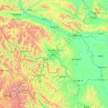
Nom : Carte topographique Maqu County, altitude, relief.
Lieu : Maqu County, Gannan, Gansu, China (33.10520 100.76286 34.38453 102.48214)
Altitude moyenne : 3 812 m
Altitude minimum : 3 305 m
Altitude maximum : 5 295 m
Autres cartes topographiques
Cliquez sur une carte pour visualiser sa topographie, son altitude et son relief.
Zhangye Danxia National Geological Park
China > Gansu > Sunan Yugur Autonomous County
The core area of the park, Linze Danxia Scenic Area, is located 30 kilometres (19 mi) west of downtown Zhangye and 20 kilometres (12 mi) south of the seat of Linze County. It is the most developed and most visited part of the park. A second scenic area, Binggou (冰沟), located on the north bank of Liyuan…
Altitude moyenne : 1 759 m