
Faire un don
Équipez-vous pour votre prochaine aventure :
En tant que Partenaire Amazon, ce site perçoit une commission sur les achats éligibles sans surcoût pour vous.
Carte topographique Maili
Cliquez sur la carte pour afficher l’altitude.
Faire un don
Équipez-vous pour votre prochaine aventure :
En tant que Partenaire Amazon, ce site perçoit une commission sur les achats éligibles sans surcoût pour vous.
Maili
Māʻili (Hawaiian pronunciation: [maːˈʔili]) is a census-designated place (CDP) in the Waiʻanae District on the island of Oʻahu, City & County of Honolulu, Hawaiʻi, United States. In Hawaiian, māʻili means "pebbly", referring to rounded stones at the shore. Māʻili is located along Farrington Highway on Oʻahu's Leeward Coast, between Māʻili Beach Park to the west and Lualualei Valley to the east. It is located 1.4 miles south of the town of Waianae, separated by the Māʻiliʻili Stream, and 1.5 miles north of Nanakuli. As of the 2020 census, the town population was 11,535. Māʻili has one 7-Eleven, a gas station, and a few residential developments. The town is also home to several dairy farms and vegetable plots. Two tall, red antennae near the mouth of the Lualualei Valley are parts of the Navcom Radio Transmitting Facility, and were the tallest man-made structures in the Western Hemisphere at 1,503 feet when they were built in 1972. The town has an elevation of 20 feet (6.1 m).
Faire un don
Équipez-vous pour votre prochaine aventure :
En tant que Partenaire Amazon, ce site perçoit une commission sur les achats éligibles sans surcoût pour vous.
À propos de cette carte
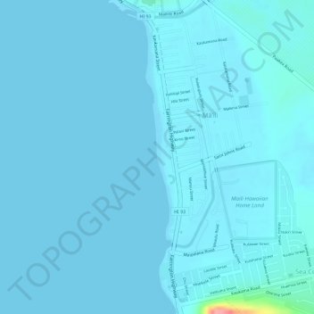
Nom : Carte topographique Maili, altitude, relief.
Altitude moyenne : 6 m
Altitude minimum : 0 m
Altitude maximum : 107 m
Faire un don
Équipez-vous pour votre prochaine aventure :
En tant que Partenaire Amazon, ce site perçoit une commission sur les achats éligibles sans surcoût pour vous.
Autres cartes topographiques
Cliquez sur une carte pour visualiser sa topographie, son altitude et son relief.