
Carte topographique Gillespies Beach
Carte interactive
Cliquez sur la carte pour afficher l’altitude.
À propos de cette carte
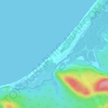
Nom : Carte topographique Gillespies Beach, altitude, relief.
Altitude moyenne : 14 m
Altitude minimum : 0 m
Altitude maximum : 121 m
Autres cartes topographiques
Cliquez sur une carte pour visualiser sa topographie, son altitude et son relief.
Okuru
New Zealand > West Coast > Westland District
Okuru, Westland District, West Coast, New Zealand
Altitude moyenne : 3 m
Hokitika
New Zealand > West Coast > Westland District
Hokitika, Westland District, West Coast, 7810, New Zealand
Altitude moyenne : 14 m
Waikowai Stream
New Zealand > West Coast > Westland District
Waikowai Stream, Westland District, West Coast, New Zealand
Altitude moyenne : 13 m
Hooker Glacier
New Zealand > West Coast > Westland District
Hooker Glacier, Westland District, West Coast, New Zealand
Altitude moyenne : 1 930 m
Belmont
New Zealand > West Coast > Westland District
Belmont, Westland District, West Coast, New Zealand
Altitude moyenne : 1 623 m
Haast
New Zealand > West Coast > Westland District
Haast, Westland District, West Coast, New Zealand
Altitude moyenne : 15 m
Fox Glacier
New Zealand > West Coast > Westland District
Fox Glacier, Westland District, West Coast, New Zealand
Altitude moyenne : 1 848 m
Franz Josef
New Zealand > West Coast > Westland District
Franz Josef, Westland District, West Coast, 7856, New Zealand
Altitude moyenne : 277 m
Mount Tasman
New Zealand > West Coast > Westland District
Mount Tasman, Westland District, West Coast, New Zealand
Altitude moyenne : 2 798 m