
Carte topographique Racovița
Carte interactive
Cliquez sur la carte pour afficher l’altitude.
À propos de cette carte
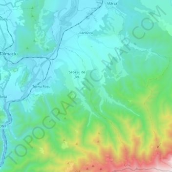
Nom : Carte topographique Racovița, altitude, relief.
Lieu : Racovița, Sibiu, Romania (45.58117 24.30931 45.70228 24.43388)
Altitude moyenne : 674 m
Altitude minimum : 350 m
Altitude maximum : 2 119 m
Racovița Commune is situated at the base of Suru Peak (2,281 m or 7,484 ft) on the contact between the foothills of the Făgăraș Mountains and the low terrace of the floodplain, on the left bank of the river Olt, at an altitude of 385 meters. The commune borders to the north and northeast with the town Avrig; the border, which extends from the confluence of the small river Mârșa with the Olt to the Sorliței Peak, was established after the year 1200 and is marked with border signs called 'morminți'.
Autres cartes topographiques
Cliquez sur une carte pour visualiser sa topographie, son altitude et son relief.
Bâlea Lake
Romania > Sibiu > Cârțișoara
Bâlea Lake, Cârțișoara, Sibiu, Romania
Altitude moyenne : 2 080 m
Lacul fără fund
Romania > Sibiu > Ocna Sibiului > Ocna Sibiului
Lacul fără fund, Ocna Sibiului, Sibiu, Romania
Altitude moyenne : 414 m
Miercurea Sibiului
Romania > Sibiu > Miercurea Sibiului
Miercurea Sibiului, Sibiu, Romania
Altitude moyenne : 432 m
Porumbacu
Romania > Sibiu > Porumbacu de Jos
Porumbacu, Porumbacu de Jos, Sibiu, 557192, Romania
Altitude moyenne : 466 m