
Carte topographique Friesach
Carte interactive
Cliquez sur la carte pour afficher l’altitude.
À propos de cette carte
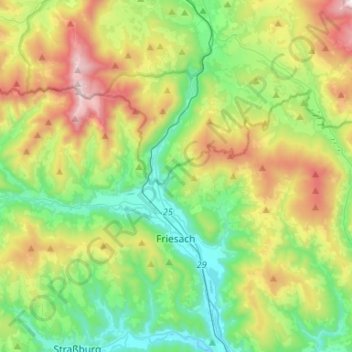
Nom : Carte topographique Friesach, altitude, relief.
Altitude moyenne : 1 044 m
Altitude minimum : 597 m
Altitude maximum : 1 945 m
Friesach covers an area of 120.83 km2 and its mean elevation is 631 meters above sea level. It is located in northern Carinthia near the border with Styria, about 40 km (25 mi) north of its capital Klagenfurt.
Autres cartes topographiques
Cliquez sur une carte pour visualiser sa topographie, son altitude et son relief.
Burg Hochosterwitz
Austria > Carinthia > Bezirk Sankt Veit an der Glan > Launsdorf > Hochosterwitz
Burg Hochosterwitz, Narrensteig, Hochosterwitz, Launsdorf, Sankt Georgen am Längsee, Bezirk Sankt Veit an der Glan, Carinthia, 9314, Austria
Altitude moyenne : 568 m
Meiselding
Austria > Carinthia > Bezirk Sankt Veit an der Glan > Meiselding
Meiselding, Mölbling, Bezirk Sankt Veit an der Glan, Carinthia, 9312, Austria
Altitude moyenne : 668 m