
Carte topographique Hohenroda
Carte interactive
Cliquez sur la carte pour afficher l’altitude.
Hohenroda
The municipality lies between the Rhön and the Thuringian Forest (ranges) in the so-called Kuppen Rhön. The highest elevation in the Hessian Skittles (a range of volcanic mountains), the Soisberg, stands at the western municipal limits.
À propos de cette carte
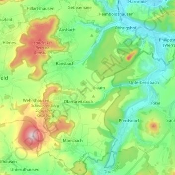
Nom : Carte topographique Hohenroda, altitude, relief.
Lieu : Hohenroda, Landkreis Hersfeld-Rotenburg, Hesse, 36284, Germany (50.76734 9.88665 50.86051 9.97804)
Altitude moyenne : 341 m
Altitude minimum : 215 m
Altitude maximum : 620 m
Autres cartes topographiques
Cliquez sur une carte pour visualiser sa topographie, son altitude et son relief.
Bad Hersfeld
Germany > Hesse > Landkreis Hersfeld-Rotenburg
The Flugplatz Johannesberg has the status of Special Airfield. The runway, some 671 m long and 18 m wide, is paved with asphalt and oriented in a north–south direction. The airfield lies on the Johannesberg in the like-named outlying centre at an elevation of 284 m above sea level.
Altitude moyenne : 281 m