
Carte topographique Pointe au Baril
Carte interactive
Cliquez sur la carte pour afficher l’altitude.
À propos de cette carte
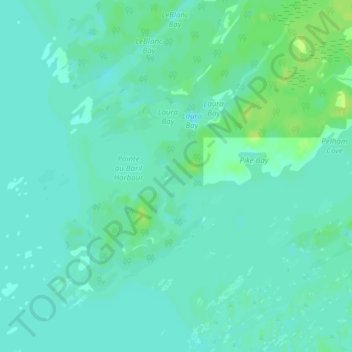
Nom : Carte topographique Pointe au Baril, altitude, relief.
Altitude moyenne : 177 m
Altitude minimum : 172 m
Altitude maximum : 186 m
Autres cartes topographiques
Cliquez sur une carte pour visualiser sa topographie, son altitude et son relief.
Deer Horn Island
Canada > Ontario > Parry Sound District > The Archipelago Township
Deer Horn Island, The Archipelago Township, Parry Sound District, Central Ontario, Ontario, Canada
Altitude moyenne : 199 m
Conger Lake
Canada > Ontario > Parry Sound District > The Archipelago Township
Conger Lake, The Archipelago Township, Parry Sound District, Central Ontario, Ontario, Canada
Altitude moyenne : 200 m
Moon River
Canada > Ontario > Parry Sound District > The Archipelago Township
Moon River, The Archipelago Township, Parry Sound District, Central Ontario, Ontario, Canada
Altitude moyenne : 185 m
Moon River
Canada > Ontario > Parry Sound District > The Archipelago Township
Moon River, The Archipelago Township, Parry Sound District, Central Ontario, Ontario, Canada
Altitude moyenne : 185 m
Watt Island
Canada > Ontario > Parry Sound District > The Archipelago Township
Watt Island, The Archipelago Township, Parry Sound District, Central Ontario, Ontario, Canada
Altitude moyenne : 195 m