
Faire un don
Équipez-vous pour votre prochaine aventure :
En tant que Partenaire Amazon, ce site perçoit une commission sur les achats éligibles sans surcoût pour vous.
Carte topographique Öhringen
Cliquez sur la carte pour afficher l’altitude.
Faire un don
Équipez-vous pour votre prochaine aventure :
En tant que Partenaire Amazon, ce site perçoit une commission sur les achats éligibles sans surcoût pour vous.
Öhringen
Öhringen is located in the western, deeper part of the Hohenlohe plain, between the Keuper stage of the Swabian-Franconian Forest and the Kocher valley. The town spreads out over the flat valley of the Ohrn, a small river, which flows about 10 kilometres (6 mi) down the valley in the district Ohrnberg into the Kocher river. The town is situated between elevation 168 metres (551 ft), in the Kocher at the county border at Möglingen, and 486 m (1,594 ft), already above the forest on the Charles Mainhardt Furter plane, which belongs to the district Michelbach. The height of the town itself varies between 215–280 metres (705–919 ft).
Faire un don
Équipez-vous pour votre prochaine aventure :
En tant que Partenaire Amazon, ce site perçoit une commission sur les achats éligibles sans surcoût pour vous.
À propos de cette carte
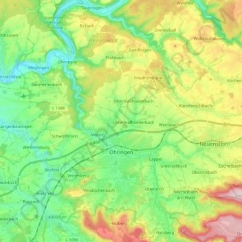
Nom : Carte topographique Öhringen, altitude, relief.
Altitude moyenne : 282 m
Altitude minimum : 168 m
Altitude maximum : 487 m
Faire un don
Équipez-vous pour votre prochaine aventure :
En tant que Partenaire Amazon, ce site perçoit une commission sur les achats éligibles sans surcoût pour vous.
Autres cartes topographiques
Cliquez sur une carte pour visualiser sa topographie, son altitude et son relief.