
Carte topographique Mica Peak
Carte interactive
Cliquez sur la carte pour afficher l’altitude.
À propos de cette carte
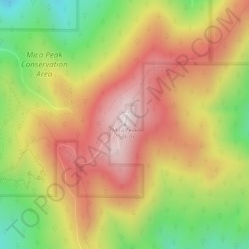
Nom : Carte topographique Mica Peak, altitude, relief.
Lieu : Mica Peak, Spokane County, Washington, United States (47.57335 -117.08174 47.57345 -117.08164)
Altitude moyenne : 1 311 m
Altitude minimum : 990 m
Altitude maximum : 1 583 m
Mica Peak is the name of two separate mountain summits in the United States located approximately 5.49 miles (9 km) apart; one in Spokane County, Washington and the other in Kootenai County, Idaho. The two peaks are located along the same ridge, which separates the Spokane Valley and Rathdrum Prairie from the Palouse. The mountains have an elevation difference of only 31 ft (9.4 m) and are the southernmost peaks of the Selkirk Mountains.
Autres cartes topographiques
Cliquez sur une carte pour visualiser sa topographie, son altitude et son relief.
Spokane
United States > Washington > Spokane County
Spokane, Spokane County, Washington, United States
Altitude moyenne : 655 m
Spokane Valley
United States > Washington > Spokane County
Spokane Valley, Spokane County, Washington, United States
Altitude moyenne : 673 m
Hampton Bay
United States > Washington > Spokane County
Hampton Bay, Spokane County, Washington, United States
Altitude moyenne : 666 m
Nine Mile Falls
United States > Washington > Spokane County
Nine Mile Falls, Spokane County, Washington, 99026, United States
Altitude moyenne : 536 m
Otis Orchards-East Farms
United States > Washington > Spokane County
Otis Orchards-East Farms, Spokane County, Washington, United States
Altitude moyenne : 668 m
Mount Spokane State Park
United States > Washington > Spokane County
Mount Spokane State Park, Spokane County, Washington, United States
Altitude moyenne : 976 m
Country Homes
United States > Washington > Spokane County
Country Homes, Spokane County, Washington, 99251, United States
Altitude moyenne : 599 m
Mead
United States > Washington > Spokane County
Mead, Spokane County, Washington, 99021, United States
Altitude moyenne : 585 m
Mica
United States > Washington > Spokane County
Mica, Spokane County, Washington, 99023, United States
Altitude moyenne : 772 m
East Spokane
United States > Washington > Spokane County > Spokane Valley > East Spokane
East Spokane, Spokane Valley, Spokane County, Washington, 99260, United States
Altitude moyenne : 625 m
Riverfront Park
United States > Washington > Spokane County > Spokane
Riverfront Park, Spokane, Spokane County, Washington, United States
Altitude moyenne : 583 m
Beacon Hill
United States > Washington > Spokane County
Beacon Hill, Spokane County, Washington, 99211, United States
Altitude moyenne : 659 m
Orchard Prairie
United States > Washington > Spokane County
Orchard Prairie, Spokane County, Washington, United States
Altitude moyenne : 682 m