
Carte topographique Drawsko Pomorskie
Carte interactive
Cliquez sur la carte pour afficher l’altitude.
À propos de cette carte
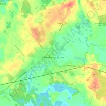
Nom : Carte topographique Drawsko Pomorskie, altitude, relief.
Altitude moyenne : 122 m
Altitude minimum : 100 m
Altitude maximum : 149 m
Autres cartes topographiques
Cliquez sur une carte pour visualiser sa topographie, son altitude et son relief.
Kalisz Pomorski
Poland > West Pomeranian Voivodeship > Drawsko County
Kalisz Pomorski, gmina Kalisz Pomorski, Drawsko County, West Pomeranian Voivodeship, 78-540, Poland
Altitude moyenne : 110 m
Ziemsko
Poland > West Pomeranian Voivodeship > Drawsko County
Ziemsko, gmina Drawsko Pomorskie, Drawsko County, West Pomeranian Voivodeship, 78-500, Poland
Altitude moyenne : 112 m
Czaplinek
Poland > West Pomeranian Voivodeship > Drawsko County
Czaplinek, gmina Czaplinek, Drawsko County, West Pomeranian Voivodeship, 78-550, Poland
Altitude moyenne : 145 m
Drawsko
Poland > West Pomeranian Voivodeship > Drawsko County > Czaplinek
Drawsko, Czaplinek, gmina Czaplinek, Drawsko County, West Pomeranian Voivodeship, Poland
Altitude moyenne : 143 m