
Carte topographique Cumbernauld
Carte interactive
Cliquez sur la carte pour afficher l’altitude.
À propos de cette carte
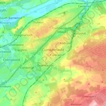
Nom : Carte topographique Cumbernauld, altitude, relief.
Lieu : Cumbernauld, North Lanarkshire, Scotland, United Kingdom (55.92079 -4.07169 55.96971 -3.93393)
Altitude moyenne : 113 m
Altitude minimum : 42 m
Altitude maximum : 223 m
Cumbernauld's name probably comes from the Gaelic comar nan allt, meaning "meeting of the burns or streams". There are differing views as to the etymology of this. One theory is that from its high point in the Central Belt, its streams flow both west to the River Clyde and east to the Firth of Forth so Cumbernauld's name is about it being on a watershed. Another theory ascribes the name to the meeting point of the Red Burn and Bog Stank streams within Cumbernauld Glen. 'Cumbernauld' is generally considered to be a Gaelic name. However, early forms containing Cumyr- hint at a Cumbric predecessor derived from *cömber, 'confluence' (c.f Welsh cymer, 'confluence'), synonymous with Aber. This seems to be suffixed with Cumbric *-ïn-alt, a topographical suffix perhaps referring to a hill or slope (Welsh yn allt, 'at a hill').
Autres cartes topographiques
Cliquez sur une carte pour visualiser sa topographie, son altitude et son relief.
Cumbernauld
United Kingdom > Scotland > North Lanarkshire > Cumbernauld
Cumbernauld, North Lanarkshire, Scotland, G67 1NG, United Kingdom
Altitude moyenne : 111 m
Shotts
United Kingdom > Scotland > North Lanarkshire
Shotts, North Lanarkshire, Scotland, ML7 4AW, United Kingdom
Altitude moyenne : 231 m
Kilsyth
United Kingdom > Scotland > North Lanarkshire
Kilsyth, North Lanarkshire, Scotland, G65 0AQ, United Kingdom
Altitude moyenne : 161 m