
Carte topographique Tver Oblast
Carte interactive
Cliquez sur la carte pour afficher l’altitude.
À propos de cette carte
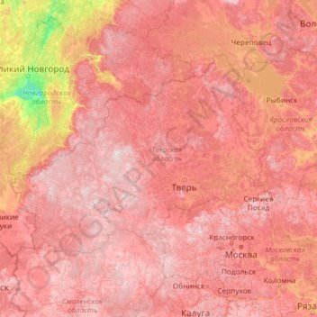
Nom : Carte topographique Tver Oblast, altitude, relief.
Lieu : Tver Oblast, Central Federal District, Russia (54.55345 32.61444 59.67345 37.73444)
Altitude moyenne : 156 m
Altitude minimum : 15 m
Altitude maximum : 332 m
Tver Oblast as a whole is characterized by flat terrain with alternating lowlands and highlands. In the western part of the province, occupying about one-third of its area is Valdai Hills, with elevations of 200–300 m above sea level. It is surrounded by depressions, lowlands have a height of 100–150 m highest point of the area has a height of 347 m, is located on a hill Tsninsky (The top of the Valdai). The low point (61 m) - the extreme north-west area of the river's edge Kunya (Russian: Кунья) on the border with the Novgorod Oblast.
Autres cartes topographiques
Cliquez sur une carte pour visualiser sa topographie, son altitude et son relief.
Kashin
Russia > Tver Oblast > Kashinsky District
Kashin, Kashinsky District, Tver Oblast, Central Federal District, Russia
Altitude moyenne : 133 m
Фёдоровское сельское поселение
Russia > Tver Oblast > Фёдоровское сельское поселение
Фёдоровское сельское поселение, Kimrsky District, Tver Oblast, Central Federal District, 171533, Russia
Altitude moyenne : 127 m
Батино
Russia > Tver Oblast > Батино
Батино, Kalininsky District, Tver Oblast, Central Federal District, Russia
Altitude moyenne : 139 m
Kashinsky District
Kashinsky District, Tver Oblast, Central Federal District, Russia
Altitude moyenne : 142 m