
Carte topographique Seia
Carte interactive
Cliquez sur la carte pour afficher l’altitude.
À propos de cette carte
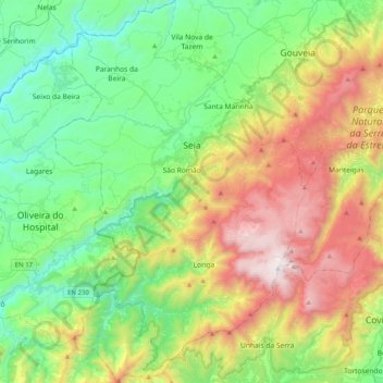
Nom : Carte topographique Seia, altitude, relief.
Lieu : Seia, Guarda, Portugal (40.22992 -7.84923 40.53552 -7.58343)
Altitude moyenne : 754 m
Altitude minimum : 150 m
Altitude maximum : 1 989 m
The municipality is limited to the north by the municipalities of Nelas and Mangualde, to the northeast by Gouveia, to the east by Manteigas, to the southeast by Covilhã, to the southwest by Arganil and to the west by Oliveira do Hospital. In this municipality is located the highest point in mainland Portugal, Torre, in Serra da Estrela, with 1,993 meters of altitude. The municipality of Seia covers a large part of Serra da Estrela and is also the only one in Portugal where there is a natural ski resort, Vodafone Ski Resort, located within the limits of the parish of Loriga.
Autres cartes topographiques
Cliquez sur une carte pour visualiser sa topographie, son altitude et son relief.