
Carte topographique Reigate
Cliquez sur la carte pour afficher l’altitude.
Reigate
Reigate is in central Surrey, around 19 mi (30 km) south of central London and 9 mi (14 km) north of Gatwick Airport. The town is in the Vale of Holmesdale, below the North Downs escarpment. The average elevation in the centre is 80 m (260 ft) above ordnance datum (OD) and the area is drained by the Wallace Brook and its tributaries, which feed the River Mole.
À propos de cette carte
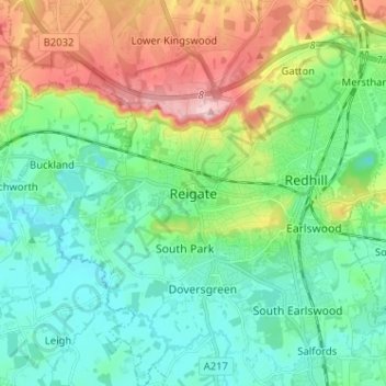
Nom : Carte topographique Reigate, altitude, relief.
Altitude moyenne : 100 m
Altitude minimum : 43 m
Altitude maximum : 236 m
Autres cartes topographiques
Cliquez sur une carte pour visualiser sa topographie, son altitude et son relief.
Lower Earlswood Lake
United Kingdom > England > Surrey > Reigate and Banstead > Redhill
Altitude moyenne : 75 m
Redhill Common
United Kingdom > England > Surrey > Reigate and Banstead > Redhill
Altitude moyenne : 92 m
Banstead Wood
United Kingdom > England > Surrey > Reigate and Banstead > Chipstead
Altitude moyenne : 145 m
Reigate Park
United Kingdom > England > Surrey > Reigate and Banstead > Reigate
Altitude moyenne : 80 m
Horley
United Kingdom > England > Surrey > Reigate and Banstead
Horley is at an altitude of around 54 m (177 ft) above mean sea level.
Altitude moyenne : 58 m