
Carte topographique Jolarpet
Carte interactive
Cliquez sur la carte pour afficher l’altitude.
À propos de cette carte
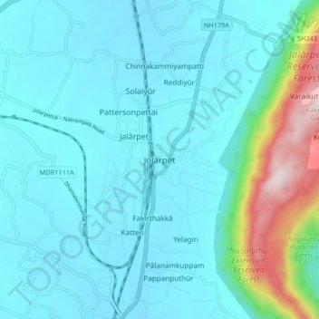
Nom : Carte topographique Jolarpet, altitude, relief.
Altitude moyenne : 493 m
Altitude minimum : 383 m
Altitude maximum : 1 117 m
Jolarpet is a second grade municipality in Tirupattur district. Jolarpet is renowned for its railway station. The town is also located on State Highway 18 connecting Vaniyambadi -Tirupattur. Regarding transportation linkage, the highway (NH 48) from Chennai to Krishnagiri passes through the outskirts of the town. Jolarpettai municipality comprises four revenue villages, namely, Vakkanampatti, Ediyampatti Ossinattam Vattam, Kudiyana Kuppam, and spreads over an area of 13.06 km2. Location of Yelagiri hills close with the town supports growth of the town to a greater extent. Almost the whole of Jolarpet Municipality consists of flat terrain. The general slope is towards southeast and the small streams that rise in the Yelagiri hills situated in the west eventually fall into the Palar river. The topography of Jolarpet in plain and it is situated at an altitude of 186.75 meters above mean sea level. The wind direction is predominant towards southwest for the whole of the year However, during summer it is from southwest to northeast.
Autres cartes topographiques
Cliquez sur une carte pour visualiser sa topographie, son altitude et son relief.
Kilkaniyūr
India > Tamil Nadu > Tirupathur
Kilkaniyūr, Tirupathur, Tirupattur District, Tamil Nadu, 635853, India
Altitude moyenne : 972 m
Perumāl Malai
India > Tamil Nadu > Tirupathur
Perumāl Malai, Tirupathur, Tirupattur District, Tamil Nadu, India
Altitude moyenne : 389 m
Yelagiri
India > Tamil Nadu > Tirupathur
Yelagiri, Tirupathur, Tirupattur District, Tamil Nadu, 635851, India
Altitude moyenne : 476 m
Kurumberi
India > Tamil Nadu > Tirupathur > Kurumberi
Kurumberi, Tirupathur, Tirupattur District, Tamil Nadu, 635652, India
Altitude moyenne : 382 m
Tirupattur
India > Tamil Nadu > Tirupathur
Tirupattur, Tirupathur, Tirupattur District, Tamil Nadu, 635600, India
Altitude moyenne : 389 m