
Faire un don
Équipez-vous pour votre prochaine aventure :
En tant que Partenaire Amazon, ce site perçoit une commission sur les achats éligibles sans surcoût pour vous.
Carte topographique Bannerghatta National Park
Cliquez sur la carte pour afficher l’altitude.
Faire un don
Équipez-vous pour votre prochaine aventure :
En tant que Partenaire Amazon, ce site perçoit une commission sur les achats éligibles sans surcoût pour vous.
Bannerghatta National Park
The 65,127.5 acre (260.51 km2) national park is located about 22 km south of Bangalore in the hills of the Anekal range with an elevation of 1245 - 1634m. The park has a hilly terrain of granite sheets under moist deciduous forest valleys and scrubland on higher areas. Sixteen villages border the park. Most of the national park consists of artificial forest, and some animals have been introduced. The park is part of a wildlife corridor for elephants which connects the BR Hills and the Sathyamangalam forest. The park is contiguous with Talli reserve forest in the southeast and Bilikal forest in the south.
Faire un don
Équipez-vous pour votre prochaine aventure :
En tant que Partenaire Amazon, ce site perçoit une commission sur les achats éligibles sans surcoût pour vous.
À propos de cette carte
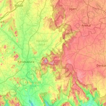
Nom : Carte topographique Bannerghatta National Park, altitude, relief.
Altitude moyenne : 782 m
Altitude minimum : 523 m
Altitude maximum : 1 152 m
Faire un don
Équipez-vous pour votre prochaine aventure :
En tant que Partenaire Amazon, ce site perçoit une commission sur les achats éligibles sans surcoût pour vous.