
Carte topographique Plitvice Lakes National Park
Carte interactive
Cliquez sur la carte pour afficher l’altitude.
À propos de cette carte
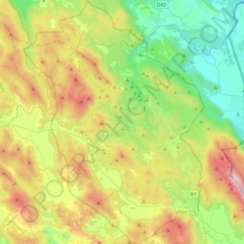
Nom : Carte topographique Plitvice Lakes National Park, altitude, relief.
Altitude moyenne : 765 m
Altitude minimum : 284 m
Altitude maximum : 1 637 m
The 16 lakes are separated into an upper and lower cluster formed by runoff from the mountains, descending from an altitude of 636 to 503 m (2,087 to 1,650 ft) over a distance of some 8 kilometres (5.0 mi), aligned in a south–north direction. The lakes collectively cover an area of about 0.77 square miles, the water exiting from the lowest lake forming the Korana River.