
Faire un don
Équipez-vous pour votre prochaine aventure :
En tant que Partenaire Amazon, ce site perçoit une commission sur les achats éligibles sans surcoût pour vous.
Carte topographique Hilltop
Cliquez sur la carte pour afficher l’altitude.
Faire un don
Équipez-vous pour votre prochaine aventure :
En tant que Partenaire Amazon, ce site perçoit une commission sur les achats éligibles sans surcoût pour vous.
À propos de cette carte
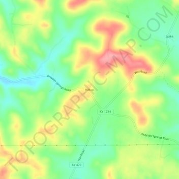
Nom : Carte topographique Hilltop, altitude, relief.
Lieu : Hilltop, Grayson County, Kentucky, United States (37.37505 -86.12719 37.41505 -86.08719)
Altitude moyenne : 215 m
Altitude minimum : 170 m
Altitude maximum : 273 m
Faire un don
Équipez-vous pour votre prochaine aventure :
En tant que Partenaire Amazon, ce site perçoit une commission sur les achats éligibles sans surcoût pour vous.
Autres cartes topographiques
Cliquez sur une carte pour visualiser sa topographie, son altitude et son relief.
Rough River Lake
United States > Kentucky > Grayson County
As the seasons change, so does the size of the Rough River Lake. During the summer the lake is about 5,100 acres (2,100 ha), has 220 miles (350 km) of shoreline, is 39 miles long, and is 65 feet (20 m) deep in the deepest portion of the lake, which includes the area around the dam. During the winter the lake…
Altitude moyenne : 183 m
Faire un don
Équipez-vous pour votre prochaine aventure :
En tant que Partenaire Amazon, ce site perçoit une commission sur les achats éligibles sans surcoût pour vous.