
Carte topographique Ypsilanti
Carte interactive
Cliquez sur la carte pour afficher l’altitude.
À propos de cette carte
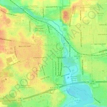
Nom : Carte topographique Ypsilanti, altitude, relief.
Lieu : Ypsilanti, Washtenaw County, Michigan, 48197, United States (42.22418 -83.65208 42.26087 -83.59643)
Altitude moyenne : 230 m
Altitude minimum : 206 m
Altitude maximum : 251 m
Autres cartes topographiques
Cliquez sur une carte pour visualiser sa topographie, son altitude et son relief.
Ann Arbor
United States > Michigan > Washtenaw County
Ann Arbor, Washtenaw County, Michigan, United States
Altitude moyenne : 268 m
Scio Township
United States > Michigan > Washtenaw County
Scio Township, Washtenaw County, Michigan, United States
Altitude moyenne : 277 m
Saline
United States > Michigan > Washtenaw County
Saline, Washtenaw County, Michigan, 48176, United States
Altitude moyenne : 248 m
Lyndon Township
United States > Michigan > Washtenaw County
Lyndon Township, Washtenaw County, Michigan, 48190, United States
Altitude moyenne : 288 m
Dexter Township
United States > Michigan > Washtenaw County > Dexter Township
Dexter Township, Washtenaw County, Michigan, United States
Altitude moyenne : 278 m