
Carte topographique Hattenhof
Carte interactive
Cliquez sur la carte pour afficher l’altitude.
À propos de cette carte
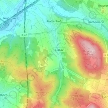
Nom : Carte topographique Hattenhof, altitude, relief.
Lieu : Hattenhof, Neuhof, Landkreis Fulda, Hessen, Duitsland (50.43136 9.65150 50.47641 9.70002)
Altitude moyenne : 350 m
Altitude minimum : 267 m
Altitude maximum : 491 m
Autres cartes topographiques
Cliquez sur une carte pour visualiser sa topographie, son altitude et son relief.
Unterbernhards
Duitsland > Hessen > Landkreis Fulda
Unterbernhards, Hilders, Landkreis Fulda, Hessen, Duitsland
Altitude moyenne : 510 m
Tann
Duitsland > Hessen > Landkreis Fulda
Tann, Landkreis Fulda, Hessen, 36142, Duitsland
Altitude moyenne : 504 m
Hilders
Duitsland > Hessen > Landkreis Fulda
Hilders, Landkreis Fulda, Hessen, 36115, Duitsland
Altitude moyenne : 577 m
Hattenhof
Duitsland > Hessen > Landkreis Fulda > Hattenhof
Hattenhof, Neuhof, Landkreis Fulda, Hessen, 36124, Duitsland
Altitude moyenne : 324 m
Rothemann
Duitsland > Hessen > Landkreis Fulda > Rothemann
Rothemann, Eichenzell, Landkreis Fulda, Hessen, 36124, Duitsland
Altitude moyenne : 338 m
Fulda
Duitsland > Hessen > Landkreis Fulda
Fulda, Landkreis Fulda, Hessen, Duitsland
Altitude moyenne : 324 m