
Carte topographique Montgomery
Carte interactive
Cliquez sur la carte pour afficher l’altitude.
Montgomery
Tekoa Mountain overlooks the Westfield River Gorge and the Connecticut River Valley. The town of Russell and its villages, Woronoco and Crescent Mills, lie at the foot of the mountain along the Westfield River. From the summit ledges, the cities of Westfield and Springfield, Massachusetts are visible to the east. The southwest and northeast sides of Tekoa Mountain are steep and rugged with frequent cliff faces and rocky overlooks; to the north, the topography gradually flattens out as Tekoa Mountain merges with the upland plateau of Montgomery. The southwest side of Tekoa Mountain drains into the Westfield River, thence into the Connecticut River and Long Island Sound; the northeast side drains into Moose Meadow Brook, thence the Westfield River.
À propos de cette carte
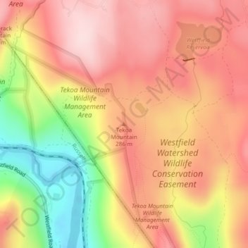
Nom : Carte topographique Montgomery, altitude, relief.
Altitude moyenne : 241 m
Altitude minimum : 65 m
Altitude maximum : 351 m
Autres cartes topographiques
Cliquez sur une carte pour visualiser sa topographie, son altitude et son relief.
Blandford
United States > Massachusetts > Hampden County
The town is located near the eastern edge of the Berkshire Hills, above an ancient rift zone where the Connecticut River Valley is downfaulted approximately 1,000 feet (300 m). The town's elevations range from about 400 feet (120 m) above sea level along streams approaching the Westfield River (a major…
Altitude moyenne : 346 m