Carte topographique Killala
Carte interactive
Cliquez sur la carte pour afficher l’altitude.
À propos de cette carte
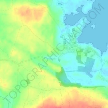
The Roman Catholic Diocese of Killala (Alladenis in Latin) is one of the five suffragan sees of the ecclesiastical Province of Tuam, comprising the north-western part of the County Mayo with the Barony of Tireragh in the County Sligo. In all there are 22 parishes, some of which, bordering on the Atlantic Ocean, consist mostly of wild moorland, sparsely inhabited. Lewis's Topographical Dictionary sets down the length of the diocese as 45 miles (72 km), the breadth 21 mi (34 km), and the estimated superficies as 314,300 acres (1,272 km2) – of which 43,100 acres (174 km2) are in County Sligo and 271,200 acres (1,098 km2) in County Mayo.
Autres cartes topographiques
Cliquez sur une carte pour visualiser sa topographie, son altitude et son relief.
Aghamore
Aghamore, Claremorris-Swinford Municipal District, County Mayo, Connacht, Ireland
Altitude moyenne : 111 m
Tooreen
Tooreen, Claremorris-Swinford Municipal District, County Mayo, Connacht, Ireland
Altitude moyenne : 97 m
Knock
Knock, Claremorris-Swinford Municipal District, County Mayo, Connacht, F12 KF89, Ireland
Altitude moyenne : 94 m
Ballinamore
Ballinamore, Ballinamore ED, Claremorris-Swinford Municipal District, County Mayo, Connacht, Ireland
Altitude moyenne : 72 m
Ballyhaunis
Ballyhaunis, Claremorris-Swinford Municipal District, County Mayo, Connacht, F35 NF82, Ireland
Altitude moyenne : 87 m
Crossboyne
Crossboyne, Crossboyne Electoral Division, Claremorris-Swinford Municipal District, County Mayo, Connacht, Ireland
Altitude moyenne : 51 m
Kilkelly
Kilkelly, Claremorris-Swinford Municipal District, County Mayo, Connacht, Ireland
Altitude moyenne : 94 m
Cong
Cong, Claremorris-Swinford Municipal District, County Mayo, Connacht, F31 XD56, Ireland
Altitude moyenne : 23 m
Downpatrick Head
Downpatrick Head, Lacken North ED, Ballina Municipal District, County Mayo, Connacht, Ireland
Altitude moyenne : 3 m
Glinsk
Glinsk, Westport-Belmullet Municipal District, County Mayo, Connacht, Ireland
Altitude moyenne : 116 m
Beltra Lough
Beltra Lough, Glenhest Electoral Division, Westport-Belmullet Municipal District, County Mayo, Connacht, Ireland
Altitude moyenne : 55 m
Ballinrobe
Ballinrobe, Ballinrobe ED, Claremorris-Swinford Municipal District, County Mayo, Connacht, Ireland
Altitude moyenne : 30 m
Faheens
Faheens, Brackloon Electoral Division, Claremorris-Swinford Municipal District, County Mayo, Connacht, Ireland
Altitude moyenne : 74 m
Kilgarriff
Kilgarriff, Doocastle ED, Claremorris-Swinford Municipal District, County Mayo, Connacht, Ireland
Altitude moyenne : 105 m
Knock
Knock, Claremorris-Swinford Municipal District, County Mayo, Connacht, F12 KF89, Ireland
Altitude moyenne : 94 m
Massbrook Upper
Massbrook Upper, Addergoole ED, Castlebar Municipal District, County Mayo, Connacht, Ireland
Altitude moyenne : 104 m
Kilmaine
Kilmaine, Kilmaine Electoral Division, Claremorris-Swinford Municipal District, County Mayo, Connacht, Ireland
Altitude moyenne : 40 m
Bellacorick
Bellacorick, Glenco Electoral Division, Westport-Belmullet Municipal District, County Mayo, Connacht, Ireland
Altitude moyenne : 85 m
Clare Island
Clare Island, Westport-Belmullet Municipal District, County Mayo, Connacht, Ireland
Altitude moyenne : 29 m
Swinford
Swinford, Swineford Electoral Division, Claremorris-Swinford Municipal District, County Mayo, Connacht, Ireland
Altitude moyenne : 65 m
Ross
Ross, Castlebar Municipal District, County Mayo, Connacht, F23 KN59, Ireland
Altitude moyenne : 63 m
Castlebar
Castlebar, Castlebar Municipal District, County Mayo, Connacht, Ireland
Altitude moyenne : 44 m
Carrowcanada
Carrowcanada, Swineford Electoral Division, Claremorris-Swinford Municipal District, County Mayo, Connacht, Ireland
Altitude moyenne : 74 m
Caher
Caher, Kilmaine Electoral Division, Claremorris-Swinford Municipal District, County Mayo, Connacht, Ireland
Altitude moyenne : 41 m
Achill Island
Achill Island, County Mayo, Connacht, F28 X018, Ireland
Altitude moyenne : 42 m
Knockaneden
Knockaneden, Islandeady Electoral Division, Castlebar Municipal District, County Mayo, Connacht, Ireland
Altitude moyenne : 52 m
Ballyglass
Ballyglass, Castlebar Municipal District, County Mayo, Connacht, Ireland
Altitude moyenne : 40 m
Leadymore
Leadymore, Kilalla ED, Ballina Municipal District, County Mayo, Connacht, Ireland
Altitude moyenne : 15 m
Mayo
Mayo, Claremorris-Swinford Municipal District, County Mayo, Connacht, F12 E7W7, Ireland
Altitude moyenne : 53 m
Kilbride
Kilbride, Lacken North ED, Ballina Municipal District, County Mayo, Connacht, Ireland
Altitude moyenne : 60 m
Bunacrower
Bunacrower, Kilmaine Electoral Division, Claremorris-Swinford Municipal District, County Mayo, Connacht, Ireland
Altitude moyenne : 37 m
Lough Conn
Lough Conn, Ballina Municipal District, County Mayo, Connacht, Ireland
Altitude moyenne : 26 m
Murneen Electoral Division
Murneen Electoral Division, Claremorris-Swinford Municipal District, County Mayo, Connacht, F12 D406, Ireland
Altitude moyenne : 77 m
Murneen North
Murneen North, Murneen Electoral Division, Claremorris-Swinford Municipal District, County Mayo, Connacht, Ireland
Altitude moyenne : 77 m
Behy Beg
Behy Beg, Ardnaree South Rural ED, Ballina Municipal District, County Mayo, Connacht, Ireland
Altitude moyenne : 27 m
Clyard
Clyard, Kilmaine Electoral Division, Claremorris-Swinford Municipal District, County Mayo, Connacht, Ireland
Altitude moyenne : 34 m
Freaghillan
Freaghillan, Ballysakeery ED, County Mayo, Connacht, Ireland
Altitude moyenne : 6 m
Killasser
Killasser, Cuildoo ED, Claremorris-Swinford Municipal District, County Mayo, Connacht, F12 DK63, Ireland
Altitude moyenne : 57 m
Kilgarvan
Kilgarvan, Sallymount ED, Ballina Municipal District, County Mayo, Connacht, Ireland
Altitude moyenne : 218 m
Claremorris-Swinford Municipal District
Claremorris-Swinford Municipal District, County Mayo, Connacht, Ireland
Altitude moyenne : 69 m
Strandhill
Strandhill, Cong Electoral Division, Claremorris-Swinford Municipal District, County Mayo, Connacht, Ireland
Altitude moyenne : 16 m
Claremorris
Ireland > County Mayo > Claremorris
Claremorris, Claremorris-Swinford Municipal District, County Mayo, Connacht, F12 RY11, Ireland
Altitude moyenne : 67 m
Dooncarton
Dooncarton, Knocknalower ED, Westport-Belmullet Municipal District, County Mayo, Connacht, Ireland
Altitude moyenne : 71 m
Lough Nacorra
Lough Nacorra, Kilsallagh ED, Westport-Belmullet Municipal District, County Mayo, Connacht, Ireland
Altitude moyenne : 207 m
Carrowmore
Carrowmore, Kilcommon Electoral Division, Claremorris-Swinford Municipal District, County Mayo, Connacht, Ireland
Altitude moyenne : 44 m
Roy
Roy, Rathhill ED, Westport-Belmullet Municipal District, County Mayo, Connacht, Ireland
Altitude moyenne : 12 m
Glencastle
Glencastle, Glencastle ED, Westport-Belmullet Municipal District, County Mayo, Connacht, Ireland
Altitude moyenne : 82 m