
Carte topographique Shayhontohur Tumani
Carte interactive
Cliquez sur la carte pour afficher l’altitude.
À propos de cette carte
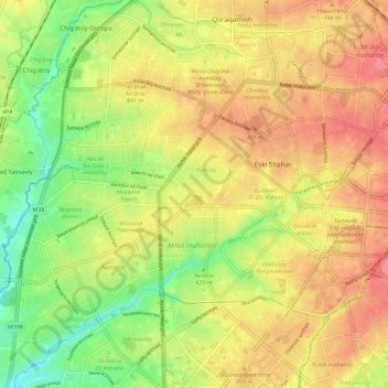
Nom : Carte topographique Shayhontohur Tumani, altitude, relief.
Lieu : Shayhontohur Tumani, Tachkent, 100000, Ouzbékistan (41.29959 69.15986 41.35014 69.27491)
Altitude moyenne : 434 m
Altitude minimum : 393 m
Altitude maximum : 467 m
Autres cartes topographiques
Cliquez sur une carte pour visualiser sa topographie, son altitude et son relief.
Shaykhontohur Tumani
Yashnobod tumani, Tachkent, Shaykhontohur Tumani, 100000, Ouzbékistan
Altitude moyenne : 448 m
Bektemir tumani
Bektemir tumani, Tachkent, 100000, Ouzbékistan
Altitude moyenne : 429 m