
Carte topographique Bjelovar
Carte interactive
Cliquez sur la carte pour afficher l’altitude.
À propos de cette carte
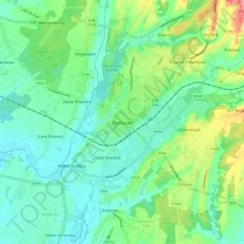
Nom : Carte topographique Bjelovar, altitude, relief.
Altitude moyenne : 147 m
Altitude minimum : 96 m
Altitude maximum : 278 m
The city of Bjelovar has an area of 181.75 km2 (70.2 sq mi), and administratively it includes 31 other areas. North-east of Bjelovar there is a long, low elevation called Bilogora, with an average height of 150–200 m (highest point: Rajčevica, 309 m). The geology of the area consists of Pliocene sandy marl and sandstones with lesser layers of lignite. Older rocks do not appear on the surface in this area. In deep boreholes there are crystalline rocks.
Autres cartes topographiques
Cliquez sur une carte pour visualiser sa topographie, son altitude et son relief.
Općina Ivanska
Croatia > Bjelovar-Bilogora County
Općina Ivanska, Bjelovar-Bilogora County, 43231, Croatia
Altitude moyenne : 152 m
Općina Rovišće
Croatia > Bjelovar-Bilogora County
Općina Rovišće, Bjelovar-Bilogora County, Croatia
Altitude moyenne : 136 m
Orovac
Croatia > Bjelovar-Bilogora County
Orovac, Bjelovar-Bilogora County, Croatia
Altitude moyenne : 146 m