
Carte topographique Asmara
Carte interactive
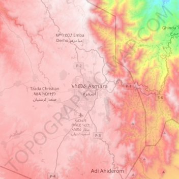
Cliquez sur la carte pour afficher l’altitude.
À propos de cette carte
Nom : Carte topographique Asmara, altitude, relief.
Lieu : Asmara, Maekel Region, Eritrea (15.17897 38.77268 15.49897 39.09268)
Altitude moyenne : 2 037 m
Altitude minimum : 564 m
Altitude maximum : 2 569 m
Asmara (/æsˈmɑːrə/ əs-MAHR-ə), or Asmera, is the capital and most populous city of Eritrea, in the country's Central Region. It sits at an elevation of 2,325 metres (7,628 ft), making it the sixth highest capital in the world by altitude and the second highest capital in Africa. The city is located at the tip of an escarpment that is both the northwestern edge of the Eritrean Highlands and the Great Rift Valley in neighbouring Ethiopia. In 2017, the city was declared as a UNESCO World Heritage Site for its well-preserved modernist architecture. The site of Asmera was first settled in 800 BC with a population ranging from 100 to 1,000. The city was then founded in the 12th century AD after four separate villages unified to live together peacefully after long periods of conflict. Under Italian rule the city of Asmara was made capital of Eritrea in the last years of the 19th century.
Autres cartes topographiques
Cliquez sur une carte pour visualiser sa topographie, son altitude et son relief.