
Carte topographique South Meadow Village
Carte interactive
Cliquez sur la carte pour afficher l’altitude.
À propos de cette carte
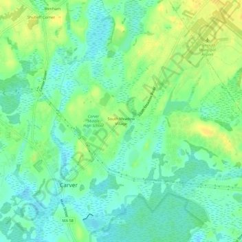
Nom : Carte topographique South Meadow Village, altitude, relief.
Altitude moyenne : 35 m
Altitude minimum : 24 m
Altitude maximum : 48 m
Autres cartes topographiques
Cliquez sur une carte pour visualiser sa topographie, son altitude et son relief.
Cranberry Village
United States > Massachusetts > Plymouth County > Carver
Cranberry Village, Carver, Plymouth County, Massachusetts, 02506, United States
Altitude moyenne : 30 m
Cole Mill
United States > Massachusetts > Plymouth County > Carver
Cole Mill, Carver, Plymouth County, Massachusetts, 02367, United States
Altitude moyenne : 34 m
Huckleberry Corner
United States > Massachusetts > Plymouth County > Carver
Huckleberry Corner, Carver, Plymouth County, Massachusetts, 02506, United States
Altitude moyenne : 26 m
Sampson Pond
United States > Massachusetts > Plymouth County > Carver > South Carver
Sampson Pond, South Carver, Carver, Plymouth County, Massachusetts, United States
Altitude moyenne : 28 m
Wenham
United States > Massachusetts > Plymouth County > Carver
Wenham, Carver, Plymouth County, Massachusetts, 02330, United States
Altitude moyenne : 38 m
South Carver
United States > Massachusetts > Plymouth County > Carver
South Carver, Carver, Plymouth County, Massachusetts, 02506, United States
Altitude moyenne : 28 m