
Carte topographique Tŝilhqox Biny (Chilko Lake)
Carte interactive
Cliquez sur la carte pour afficher l’altitude.
À propos de cette carte
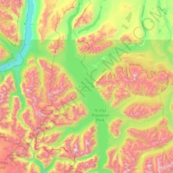
Nom : Carte topographique Tŝilhqox Biny (Chilko Lake), altitude, relief.
Altitude moyenne : 1 738 m
Altitude minimum : 787 m
Altitude maximum : 3 160 m
Tŝilhqox Biny (Pronounced: Tsyle-koh Bee), known as Chilko Lake, is a 180 km2 lake in west-central British Columbia, at the head of the Chilko River on the Chilcotin Plateau. The lake is about 65 km long, with a southwest arm 10 km long. It is one of the largest lakes by volume in the province because of its great depth, and the largest above 1,000 m in elevation. It and Harrison Lake are the largest lakes in the southern Coast Mountains.
Autres cartes topographiques
Cliquez sur une carte pour visualiser sa topographie, son altitude et son relief.
Nemaiah Valley
Canada > British Columbia > Cariboo Regional District > Area J (West Chilcotin)
Nemaiah Valley, Area J (West Chilcotin), Cariboo Regional District, British Columbia, V0L 1X0, Canada
Altitude moyenne : 1 270 m
Asperity Mountain
Canada > British Columbia > Cariboo Regional District > Area J (West Chilcotin)
Asperity Mountain, Area J (West Chilcotin), Cariboo Regional District, British Columbia, Canada
Altitude moyenne : 2 990 m